Topografische Karte El Raso
Interaktive Karte
Klicken Sie auf die Karte, um die Höhe anzuzeigen.
Über diese Karte
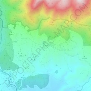
Name: Topografische Karte El Raso, Höhe, Relief.
Ort: El Raso, Candeleda, Ávila, Castilla y León, 05489, España (40.15051 -5.35958 40.19051 -5.31958)
Durchschnittliche Höhe: 555 m
Minimale Höhe: 342 m
Maximale Höhe: 1’085 m
Andere topografische Karten
Klicken Sie auf eine Karte, um ihre Topografie, ihre Höhe und ihr Relief anzuzeigen.
Sistema Central
España > Castilla y León > Candeleda
Sistema Central, Candeleda, Ávila, Castilla y León, España
Durchschnittliche Höhe: 2’191 m
Puerto de Candeleda
España > Castilla y León > Candeleda
Puerto de Candeleda, Candeleda, Ávila, Castilla y León, España
Durchschnittliche Höhe: 1’884 m
Navasomera
España > Castilla y León > Candeleda
Navasomera, Candeleda, Ávila, Castilla y León, España
Durchschnittliche Höhe: 2’033 m
Pico Almanzor
España > Castilla y León > Candeleda
Pico Almanzor, Candeleda, Ávila, Castilla y León, España
Durchschnittliche Höhe: 2’159 m