
Spenden
Rüste dich für dein nächstes Abenteuer:
Als Amazon-Partner verdient diese Seite an qualifizierten Käufen, ohne dass Ihnen zusätzliche Kosten entstehen.
Topografische Karte Cawayan
Klicken Sie auf die Karte, um die Höhe anzuzeigen.
Spenden
Rüste dich für dein nächstes Abenteuer:
Als Amazon-Partner verdient diese Seite an qualifizierten Käufen, ohne dass Ihnen zusätzliche Kosten entstehen.
Cawayan
The locals of Cawayan still largely depend on subsistence farming despite its topographic advantage to adapt commercial farming. The lack of funding for agriculture and infrastructure and its political insecurity due to the presence and activities of armed groups kept by political families[19] and other subversive elements hinder the town's progress in spite of its geographical benefits.
Spenden
Rüste dich für dein nächstes Abenteuer:
Als Amazon-Partner verdient diese Seite an qualifizierten Käufen, ohne dass Ihnen zusätzliche Kosten entstehen.
Über diese Karte
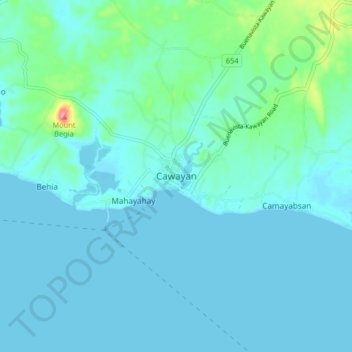
Name: Topografische Karte Cawayan, Höhe, Relief.
Ort: Cawayan, Masbate, Bicol Region, 5409, Philippines (11.89013 123.72923 11.97013 123.80923)
Durchschnittliche Höhe: 12 m
Minimale Höhe: -1 m
Maximale Höhe: 97 m
Spenden
Rüste dich für dein nächstes Abenteuer:
Als Amazon-Partner verdient diese Seite an qualifizierten Käufen, ohne dass Ihnen zusätzliche Kosten entstehen.