
Topografische Karte Deddington
Interaktive Karte
Klicken Sie auf die Karte, um die Höhe anzuzeigen.
Über diese Karte
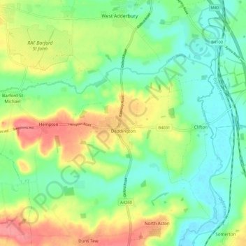
Name: Topografische Karte Deddington, Höhe, Relief.
Durchschnittliche Höhe: 107 m
Minimale Höhe: 75 m
Maximale Höhe: 159 m
Clifton, Deddington and Hempton stand on a ridge of Jurassic ferruginous marlstone hills between the three watercourses. Clifton is about 1+1⁄2 miles (2.4 km) east of Deddington, at the eastern end of the ridge where it slopes down to the Cherwell. The ridges rises westward. Deddington is about 430 feet (130 m) above sea level. Hempton is about 1+1⁄2 miles (2.4 km) west of Deddington and about 489 feet (149 m) above sea level. The highest point of the ridge is on the western boundary of the parish, more than 490 feet (150 m) above sea level. The parish's topography is alluded to in a local rhyme:
Andere topografische Karten
Klicken Sie auf eine Karte, um ihre Topografie, ihre Höhe und ihr Relief anzuzeigen.
Ambrosden
United Kingdom > England > Oxfordshire > Cherwell District
Ambrosden, Cherwell District, Oxfordshire, England, United Kingdom
Durchschnittliche Höhe: 66 m
Cottisford
United Kingdom > England > Oxfordshire > Cherwell District
Cottisford, Cherwell District, Oxfordshire, England, United Kingdom
Durchschnittliche Höhe: 121 m
Launton
United Kingdom > England > Oxfordshire > Cherwell District
Launton, Cherwell District, Oxfordshire, England, United Kingdom
Durchschnittliche Höhe: 73 m
Kirtlington
United Kingdom > England > Oxfordshire > Cherwell District
Kirtlington, Cherwell District, Oxfordshire, England, United Kingdom
Durchschnittliche Höhe: 89 m
Bicester
United Kingdom > England > Oxfordshire > Cherwell District
Bicester, Cherwell District, Oxfordshire, England, United Kingdom
Durchschnittliche Höhe: 76 m
Adderbury
United Kingdom > England > Oxfordshire > Cherwell District
Adderbury, Cherwell District, Oxfordshire, England, United Kingdom
Durchschnittliche Höhe: 100 m
Banbury
United Kingdom > England > Oxfordshire > Cherwell District
Banbury, Cherwell District, Oxfordshire, England, United Kingdom
Durchschnittliche Höhe: 116 m