
Topografische Karte Άλσος Βεΐκου
Interaktive Karte
Klicken Sie auf die Karte, um die Höhe anzuzeigen.
Über diese Karte
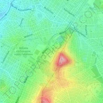
Name: Topografische Karte Άλσος Βεΐκου, Höhe, Relief.
Durchschnittliche Höhe: 171 m
Minimale Höhe: 109 m
Maximale Höhe: 301 m
Andere topografische Karten
Klicken Sie auf eine Karte, um ihre Topografie, ihre Höhe und ihr Relief anzuzeigen.
Lycabettus
Greece > Attica > Regional Unit of Central Athens > Athens
Lycabettus, Δώρας Δ' Ίστρια, Kolonaki, Συνοικία Κολωνακίου, 1st District of Athens, Athens, Municipality of Athens, Regional Unit of Central Athens, Attica, 106 76, Greece
Durchschnittliche Höhe: 125 m
Dourgouti Region
Greece > Attica > Regional Unit of Central Athens > Athens
Dourgouti Region, Dourgouti, 2nd District of Athens, Athens, Municipality of Athens, Regional Unit of Central Athens, Attica, Greece
Durchschnittliche Höhe: 73 m
Philopappos Hill
Greece > Attica > Regional Unit of Central Athens > Athens
Philopappos Hill, Athens, Municipality of Athens, Regional Unit of Central Athens, Attica, 117 41, Greece
Durchschnittliche Höhe: 73 m
Ιλισσός
Greece > Attica > Regional Unit of Central Athens > Athens
Ιλισσός, 7th District of Athens, Athens, Municipality of Athens, Regional Unit of Central Athens, Attica, 11527, Greece
Durchschnittliche Höhe: 140 m