
Topografische Karte Bajo Maestrazgo
Interaktive Karte
Klicken Sie auf die Karte, um die Höhe anzuzeigen.
Über diese Karte
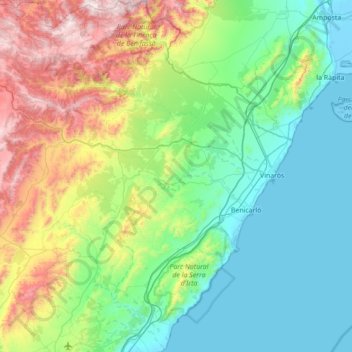
Name: Topografische Karte Bajo Maestrazgo, Höhe, Relief.
Ort: Bajo Maestrazgo, Castellón, Comunidad Valenciana, España (40.20352 -0.01025 40.73324 0.51545)
Durchschnittliche Höhe: 343 m
Minimale Höhe: -5 m
Maximale Höhe: 1’362 m
Andere topografische Karten
Klicken Sie auf eine Karte, um ihre Topografie, ihre Höhe und ihr Relief anzuzeigen.
Masía de la Pereta
España > Comunidad Valenciana > Castellón > Villahermosa del Río
Masía de la Pereta, Villahermosa del Río, El Alto Mijares, Castellón, Comunidad Valenciana, España
Durchschnittliche Höhe: 987 m
San Rafael del Río
España > Comunidad Valenciana > Castellón > San Rafael del Río
San Rafael del Río, Bajo Maestrazgo, Castellón, Comunidad Valenciana, 12510, España
Durchschnittliche Höhe: 224 m
Villavieja
España > Comunidad Valenciana > Castellón
Villavieja, Plana Baja, Castellón, Comunidad Valenciana, 12526, España
Durchschnittliche Höhe: 66 m