
Topografische Karte Gifford Pinchot National Forest
Interaktive Karte
Klicken Sie auf die Karte, um die Höhe anzuzeigen.
Über diese Karte
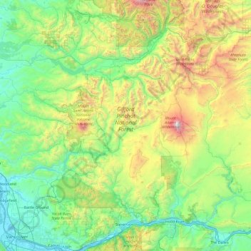
Name: Topografische Karte Gifford Pinchot National Forest, Höhe, Relief.
Durchschnittliche Höhe: 769 m
Minimale Höhe: -1 m
Maximale Höhe: 3’703 m
Gifford Pinchot National Forest is located in a mountainous region approximately between Mount St. Helens to the west, Mount Adams to the east, Mount Rainier National Park to the north, and the Columbia River to the south. This region of Southwest Washington is noted for its complex topography and volcanic geology. About 65 percent of the forest acreage is located in Skamania County. In descending order of land area the others are Lewis, Yakima, Cowlitz, and Klickitat counties.
Andere topografische Karten
Klicken Sie auf eine Karte, um ihre Topografie, ihre Höhe und ihr Relief anzuzeigen.
Spirit Lake
United States > Washington > Skamania County
Spirit Lake, Skamania County, Washington, United States
Durchschnittliche Höhe: 1’144 m
Mount Saint Helens
United States > Washington > Skamania County
Mount Saint Helens, Skamania County, Washington, United States
Durchschnittliche Höhe: 2’096 m