
Topografische Karte Granite
Interaktive Karte
Klicken Sie auf die Karte, um die Höhe anzuzeigen.
Über diese Karte
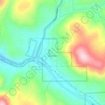
Name: Topografische Karte Granite, Höhe, Relief.
Ort: Granite, Grant County, Oregon, United States (44.80650 -118.42654 44.81395 -118.41103)
Durchschnittliche Höhe: 1’475 m
Minimale Höhe: 1’381 m
Maximale Höhe: 1’654 m
Andere topografische Karten
Klicken Sie auf eine Karte, um ihre Topografie, ihre Höhe und ihr Relief anzuzeigen.
Robinsonville
United States > Oregon > Grant County
Robinsonville, Grant County, Oregon, United States
Durchschnittliche Höhe: 1’858 m
Austin
United States > Oregon > Grant County
Austin, Grant County, Oregon, United States
Durchschnittliche Höhe: 1’312 m
Monument
United States > Oregon > Grant County
Monument, Grant County, Oregon, United States
Durchschnittliche Höhe: 640 m
Kimberly
United States > Oregon > Grant County
Kimberly, Grant County, Oregon, United States
Durchschnittliche Höhe: 711 m
John Day
United States > Oregon > Grant County
John Day, Grant County, Oregon, 97845, United States
Durchschnittliche Höhe: 1’047 m
Desolation Butte
United States > Oregon > Grant County
Desolation Butte, Grant County, Oregon, United States
Durchschnittliche Höhe: 1’949 m
Rabbit Ears
United States > Oregon > Grant County
Rabbit Ears, Grant County, Oregon, United States
Durchschnittliche Höhe: 2’285 m
Canyon City
United States > Oregon > Grant County
Canyon City, Grant County, Oregon, 97820, United States
Durchschnittliche Höhe: 1’078 m
Prairie City
United States > Oregon > Grant County > Prairie City
Prairie City, Grant County, Oregon, United States
Durchschnittliche Höhe: 1’104 m