
Topografische Karte Chobham
Klicken Sie auf die Karte, um die Höhe anzuzeigen.
Chobham
The rolling basin below reaches lowest elevations of between 30 metres (98 ft) in the centre of the west and 20 metres (66 ft) where the rivers join in the centre of the east. The rivers at the western point are less than 100 metres (330 ft) apart; to the east end of the parish where the parish adjoins the landscape of the McLaren Technology Centre the rivers are finally merged along that boundary.
Über diese Karte
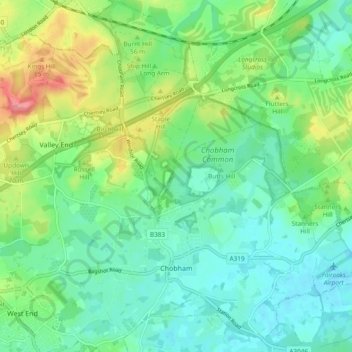
Name: Topografische Karte Chobham, Höhe, Relief.
Ort: Chobham, Surrey Heath, Surrey, England, United Kingdom (51.33363 -0.64098 51.39246 -0.54851)
Durchschnittliche Höhe: 43 m
Minimale Höhe: 19 m
Maximale Höhe: 99 m
Andere topografische Karten
Klicken Sie auf eine Karte, um ihre Topografie, ihre Höhe und ihr Relief anzuzeigen.
Camberley
United Kingdom > England > Surrey > Surrey Heath
The Staff College, to the north of Camberley town centre, is part of the Joint Services Command and Staff College, which provides training and education for established officers in the British Armed Forces and civil servants in the Ministry of Defence. The institution has its origins in the Royal Military…
Durchschnittliche Höhe: 88 m
Bagshot Park Mansion
United Kingdom > England > Surrey > Surrey Heath > Bagshot
Durchschnittliche Höhe: 76 m
Crawley Hill
United Kingdom > England > Surrey > Surrey Heath > Camberley
Durchschnittliche Höhe: 91 m
Frimley Lodge Park
United Kingdom > England > Surrey > Surrey Heath > Frimley Green
Durchschnittliche Höhe: 80 m
Kalima Caravan Site
United Kingdom > England > Surrey > Surrey Heath > Chobham
Durchschnittliche Höhe: 28 m
Dunstall Green
United Kingdom > England > Surrey > Surrey Heath > Chobham
Durchschnittliche Höhe: 33 m
Camberley
United Kingdom > England > Surrey > Surrey Heath
The Staff College, to the north of Camberley town centre, is part of the Joint Services Command and Staff College, which provides training and education for established officers in the British Armed Forces and civil servants in the Ministry of Defence. The institution has its origins in the Royal Military…
Durchschnittliche Höhe: 88 m