
Topografische Karte Maletto
Interaktive Karte
Klicken Sie auf die Karte, um die Höhe anzuzeigen.
Über diese Karte
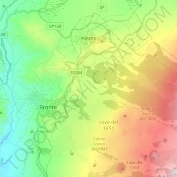
Name: Topografische Karte Maletto, Höhe, Relief.
Ort: Maletto, Catania, Sicily, 95035, Italy (37.75103 14.85167 37.84702 14.99403)
Durchschnittliche Höhe: 983 m
Minimale Höhe: 458 m
Maximale Höhe: 1’855 m
The geographical location of Maletto also influences its climate. The town experiences a Mediterranean climate, characterized by hot, dry summers and mild, rainy winters. However, due to its proximity to Mount Etna, microclimates can be observed, with variations in temperature and precipitation depending on altitude and local conditions.
Andere topografische Karten
Klicken Sie auf eine Karte, um ihre Topografie, ihre Höhe und ihr Relief anzuzeigen.
Zafferana Etnea
Zafferana Etnea, Catania, Sicily, 95019, Italy
Durchschnittliche Höhe: 771 m
Biancavilla
Biancavilla, Catania, Sicily, 95033, Italy
Durchschnittliche Höhe: 687 m
Mofeta dei Palici
Italy > Sicily > Catania > Mineo
Mofeta dei Palici, Mineo, Catania, Sicily, 95044, Italy
Durchschnittliche Höhe: 125 m
Etna
Italy > Sicily > Catania > Zafferana Etnea
Etna, Zafferana Etnea, Catania, Sicily, 95019, Italy
Durchschnittliche Höhe: 2’976 m
Mount Etna
Mount Etna, Catania, Sicily, 95036, Italy
Durchschnittliche Höhe: 1’157 m