
Topografische Karte Tempe
Interaktive Karte
Klicken Sie auf die Karte, um die Höhe anzuzeigen.
Über diese Karte
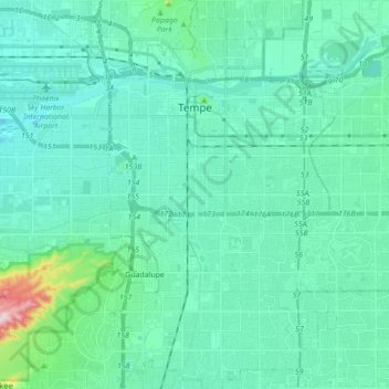
Name: Topografische Karte Tempe, Höhe, Relief.
Ort: Tempe, Maricopa County, Arizona, United States (33.32004 -111.97849 33.46533 -111.87743)
Durchschnittliche Höhe: 370 m
Minimale Höhe: 317 m
Maximale Höhe: 708 m
Tempe is generally flat, except for Hayden Butte (generally known as A-Mountain for Arizona State University's "A" logo located on its south face), located next to Sun Devil Stadium, Twin Buttes and Bell Butte on the western edge of Tempe, and Papago Park northwest of Tempe, inside Phoenix. Elevation ranges from 1,140 feet (350 m) at Tempe Town Lake to 1,495 feet (456 m) atop Hayden Butte.
Andere topografische Karten
Klicken Sie auf eine Karte, um ihre Topografie, ihre Höhe und ihr Relief anzuzeigen.
Tolleson
United States > Arizona > Maricopa County
Tolleson, Maricopa County, Arizona, United States
Durchschnittliche Höhe: 310 m
Hollis Park
United States > Arizona > Maricopa County > Tempe
Hollis Park, Tempe, Maricopa County, Arizona, United States
Durchschnittliche Höhe: 362 m
Peoria
United States > Arizona > Maricopa County
Peoria, Maricopa County, Arizona, United States
Durchschnittliche Höhe: 505 m
Mesa
United States > Arizona > Maricopa County
Mesa, Maricopa County, Arizona, 85201, United States
Durchschnittliche Höhe: 399 m
Youngtown
United States > Arizona > Maricopa County
Youngtown, Maricopa County, Arizona, 85363, United States
Durchschnittliche Höhe: 341 m
Glendale
United States > Arizona > Maricopa County
Glendale, Maricopa County, Arizona, United States
Durchschnittliche Höhe: 380 m
New River
United States > Arizona > Maricopa County > Phoenix
New River, Phoenix, Maricopa County, Arizona, United States
Durchschnittliche Höhe: 690 m
Phoenix
United States > Arizona > Maricopa County
Phoenix, Maricopa County, Arizona, United States
Durchschnittliche Höhe: 481 m
Mesa
United States > Arizona > Maricopa County
Mesa, Maricopa County, Arizona, United States
Durchschnittliche Höhe: 385 m
Avondale
United States > Arizona > Maricopa County
Avondale, Maricopa County, Arizona, United States
Durchschnittliche Höhe: 339 m
Litchfield Park
United States > Arizona > Maricopa County
Litchfield Park, Maricopa County, Arizona, United States
Durchschnittliche Höhe: 319 m
Chandler
United States > Arizona > Maricopa County
Chandler, Maricopa County, Arizona, United States
Durchschnittliche Höhe: 372 m