
Topografische Karte Prudnik
Interaktive Karte
Klicken Sie auf die Karte, um die Höhe anzuzeigen.
Über diese Karte
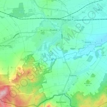
Name: Topografische Karte Prudnik, Höhe, Relief.
Durchschnittliche Höhe: 282 m
Minimale Höhe: 228 m
Maximale Höhe: 448 m
In the 19th century, the city's name was changed to Neustadt in Oberschlesien ("New Town in Upper Silesia"), while the Slavic name Prudnik was still used by its Polish inhabitants, which was mentioned in Upper Silesia's topographical description from 1865: "Der ursprünglische Stadtname „Prudnik" ist noch jetz bei den polnischen Landbewohnern üblich". In the alphabetic list of cities of Silesia published by Johann Knie in Wrocław in 1830, Polish name Prudnik was used along with German Neustadt ("Prudnik, polnische Benennung der Kreistadt Neustadt").