Geolokalisieren

Topografische Karte Everett

Interaktive Karte

Klicken Sie auf die Karte, um die Höhe anzuzeigen.

Über diese Karte

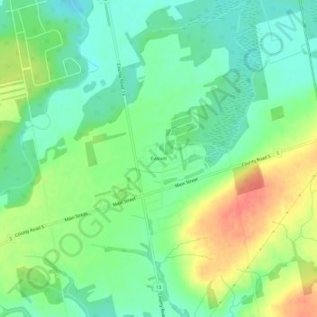
Name: Topografische Karte Everett, Höhe, Relief.

Ort: Everett, Adjala–Tosorontio, New Tecumseth, Simcoe County, Central Ontario, Ontario, L0M 1J0, Canada (44.17561 -79.95775 44.21561 -79.91775)

Durchschnittliche Höhe: 246 m

Minimale Höhe: 224 m

Maximale Höhe: 281 m

Andere topografische Karten

Klicken Sie auf eine Karte, um ihre Topografie, ihre Höhe und ihr Relief anzuzeigen.

Hockley Village

Canada > Ontario > Simcoe County > Adjala–Tosorontio

Hockley Village, Adjala–Tosorontio, Simcoe County, Central Ontario, Ontario, Canada

Durchschnittliche Höhe: 298 m

Oak Ridges

Canada > Ontario > Simcoe County > Adjala–Tosorontio

Oak Ridges, Adjala–Tosorontio, New Tecumseth, Simcoe County, Central Ontario, Ontario, L0M 1J0, Canada

Durchschnittliche Höhe: 269 m