
Spenden
Rüste dich für dein nächstes Abenteuer:
Als Amazon-Partner verdient diese Seite an qualifizierten Käufen, ohne dass Ihnen zusätzliche Kosten entstehen.
Topografische Karte Wilmington
Klicken Sie auf die Karte, um die Höhe anzuzeigen.
Spenden
Rüste dich für dein nächstes Abenteuer:
Als Amazon-Partner verdient diese Seite an qualifizierten Käufen, ohne dass Ihnen zusätzliche Kosten entstehen.
Wilmington
On the western side of Market Street, the Piedmont topography is rocky and hilly, rising to a point that marks the watershed between the Brandywine River and the Christina River. This watershed line runs along Delaware Avenue westward from 10th Street and Market Street.
Spenden
Rüste dich für dein nächstes Abenteuer:
Als Amazon-Partner verdient diese Seite an qualifizierten Käufen, ohne dass Ihnen zusätzliche Kosten entstehen.
Über diese Karte
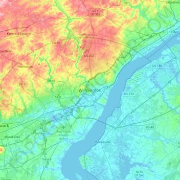
Name: Topografische Karte Wilmington, Höhe, Relief.
Durchschnittliche Höhe: 43 m
Minimale Höhe: -5 m
Maximale Höhe: 170 m
Spenden
Rüste dich für dein nächstes Abenteuer:
Als Amazon-Partner verdient diese Seite an qualifizierten Käufen, ohne dass Ihnen zusätzliche Kosten entstehen.
Andere topografische Karten
Klicken Sie auf eine Karte, um ihre Topografie, ihre Höhe und ihr Relief anzuzeigen.
Cool Spring Reservoir
United States > Delaware > New Castle County > Wilmington
Durchschnittliche Höhe: 38 m