
Spenden
Rüste dich für dein nächstes Abenteuer:
Als Amazon-Partner verdient diese Seite an qualifizierten Käufen, ohne dass Ihnen zusätzliche Kosten entstehen.
Topografische Karte Burleson
Klicken Sie auf die Karte, um die Höhe anzuzeigen.
Spenden
Rüste dich für dein nächstes Abenteuer:
Als Amazon-Partner verdient diese Seite an qualifizierten Käufen, ohne dass Ihnen zusätzliche Kosten entstehen.
Burleson
As of 2010, Burleson had a total area of 26.07 square miles (67.52 km2), of which 26.01 square miles (67.36 km2) were land and 0.07 square miles (0.17 km2), or 0.25%, were water. Village Creek, a tributary of the Trinity River, flows to the northeast through the city. Most of Burleson lies between 700 and 800 feet (210 and 240 m) in elevation.
Spenden
Rüste dich für dein nächstes Abenteuer:
Als Amazon-Partner verdient diese Seite an qualifizierten Käufen, ohne dass Ihnen zusätzliche Kosten entstehen.
Über diese Karte
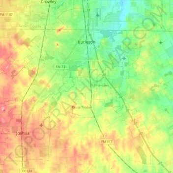
Name: Topografische Karte Burleson, Höhe, Relief.
Ort: Burleson, Johnson County, Texas, United States (32.43272 -97.43155 32.57192 -97.24890)
Durchschnittliche Höhe: 244 m
Minimale Höhe: 193 m
Maximale Höhe: 312 m
Spenden
Rüste dich für dein nächstes Abenteuer:
Als Amazon-Partner verdient diese Seite an qualifizierten Käufen, ohne dass Ihnen zusätzliche Kosten entstehen.
Andere topografische Karten
Klicken Sie auf eine Karte, um ihre Topografie, ihre Höhe und ihr Relief anzuzeigen.