
Topografische Karte Ash Grove
Interaktive Karte
Klicken Sie auf die Karte, um die Höhe anzuzeigen.
Über diese Karte
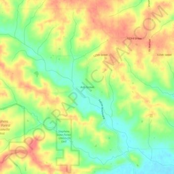
Name: Topografische Karte Ash Grove, Höhe, Relief.
Ort: Ash Grove, Davis County, Iowa, United States (40.85085 -92.57297 40.89085 -92.53297)
Durchschnittliche Höhe: 247 m
Minimale Höhe: 215 m
Maximale Höhe: 276 m
Andere topografische Karten
Klicken Sie auf eine Karte, um ihre Topografie, ihre Höhe und ihr Relief anzuzeigen.
Pulaski
United States > Iowa > Davis County
Pulaski, Davis County, Iowa, United States
Durchschnittliche Höhe: 250 m
Drakesville
United States > Iowa > Davis County
Drakesville, Davis County, Iowa, United States
Durchschnittliche Höhe: 262 m
Chequest
United States > Iowa > Davis County
Chequest, Davis County, Iowa, United States
Durchschnittliche Höhe: 232 m
Floris
United States > Iowa > Davis County
Floris, Davis County, Iowa, United States
Durchschnittliche Höhe: 218 m
West Grove
United States > Iowa > Davis County
West Grove, Davis County, Iowa, United States
Durchschnittliche Höhe: 281 m
Troy
United States > Iowa > Davis County
Troy, Davis County, Iowa, United States
Durchschnittliche Höhe: 237 m
Bloomfield
United States > Iowa > Davis County
Bloomfield, Davis County, Iowa, United States
Durchschnittliche Höhe: 261 m
Blackhawk
United States > Iowa > Davis County
Blackhawk, Davis County, Iowa, United States
Durchschnittliche Höhe: 243 m