
Topografische Karte Abbeville
Interaktive Karte
Klicken Sie auf die Karte, um die Höhe anzuzeigen.
Über diese Karte
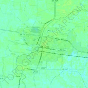
Name: Topografische Karte Abbeville, Höhe, Relief.
Ort: Abbeville, Vermilion Parish, Louisiana, 70510, United States (29.95691 -92.16533 29.99695 -92.07840)
Durchschnittliche Höhe: 5 m
Minimale Höhe: -1 m
Maximale Höhe: 9 m
Abbeville is located at 29°58′31.422″N 92°7′37.7652″W / 29.97539500°N 92.127157000°W / 29.97539500; -92.127157000 and has an elevation of 16 feet (4.9 m). According to the United States Census Bureau, the town has a total area of 5.7 square miles (14.7629 km2), of which 5.7 square miles (15 km2) is land and 0.04 square miles (0.10 km2) (0.53%) is water. Abbeville is located near the southern terminus of U.S. Highway 167. Abbeville Chris Crusta Memorial Airport is in the eastern part of the city. The Vermilion River runs through downtown, and several canals and coulees run through other parts of Abbeville.
Andere topografische Karten
Klicken Sie auf eine Karte, um ihre Topografie, ihre Höhe und ihr Relief anzuzeigen.
Kaplan
United States > Louisiana > Vermilion Parish
Kaplan, Vermilion Parish, Louisiana, United States
Durchschnittliche Höhe: 5 m
Indian Bayou
United States > Louisiana > Vermilion Parish
Indian Bayou, Vermilion Parish, Louisiana, United States
Durchschnittliche Höhe: 7 m
Rose Hill
United States > Louisiana > Vermilion Parish > Rose Hill
Rose Hill, Vermilion Parish, Louisiana, 70575, United States
Durchschnittliche Höhe: 3 m