
Topografische Karte Frontier Town
Interaktive Karte
Klicken Sie auf die Karte, um die Höhe anzuzeigen.
Über diese Karte
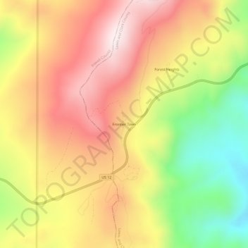
Name: Topografische Karte Frontier Town, Höhe, Relief.
Durchschnittliche Höhe: 1’870 m
Minimale Höhe: 1’519 m
Maximale Höhe: 2’157 m
Andere topografische Karten
Klicken Sie auf eine Karte, um ihre Topografie, ihre Höhe und ihr Relief anzuzeigen.
Helena
United States > Montana > Lewis and Clark County
Helena, Lewis and Clark County, Montana, United States
Durchschnittliche Höhe: 1’296 m
Craig
United States > Montana > Lewis and Clark County
Craig, Lewis and Clark County, Montana, United States
Durchschnittliche Höhe: 1’096 m
Augusta
United States > Montana > Lewis and Clark County > Augusta
Augusta, Lewis and Clark County, Montana, 59410, United States
Durchschnittliche Höhe: 1’246 m
Broadwater
United States > Montana > Lewis and Clark County
Broadwater, Lewis and Clark County, Montana, 59636, United States
Durchschnittliche Höhe: 1’284 m
York
United States > Montana > Lewis and Clark County
York, Lewis and Clark County, Montana, United States
Durchschnittliche Höhe: 1’348 m
Sugar Loaf
United States > Montana > Lewis and Clark County
Sugar Loaf, Lewis and Clark County, Montana, United States
Durchschnittliche Höhe: 1’881 m
Devils Tower
United States > Montana > Lewis and Clark County
Devils Tower, Lewis and Clark County, Montana, United States
Durchschnittliche Höhe: 1’373 m
Canyon Point
United States > Montana > Lewis and Clark County
Canyon Point, Lewis and Clark County, Montana, United States
Durchschnittliche Höhe: 2’081 m
Mount Helena
United States > Montana > Lewis and Clark County > Helena
Mount Helena, Helena, Lewis and Clark County, Montana, 59601, United States
Durchschnittliche Höhe: 1’388 m