
Spenden
Rüste dich für dein nächstes Abenteuer:
Als Amazon-Partner verdient diese Seite an qualifizierten Käufen, ohne dass Ihnen zusätzliche Kosten entstehen.
Topografische Karte Newport County
Klicken Sie auf die Karte, um die Höhe anzuzeigen.
Spenden
Rüste dich für dein nächstes Abenteuer:
Als Amazon-Partner verdient diese Seite an qualifizierten Käufen, ohne dass Ihnen zusätzliche Kosten entstehen.
Newport County
The county consists of Aquidneck Island, Conanicut Island, Prudence Island, and the easternmost portion of the state on the mainland. The highest point in the county is Pocasset Hill, 320 feet (98 m) above sea level, located in Tiverton. The lowest elevation is at sea level.
Spenden
Rüste dich für dein nächstes Abenteuer:
Als Amazon-Partner verdient diese Seite an qualifizierten Käufen, ohne dass Ihnen zusätzliche Kosten entstehen.
Über diese Karte
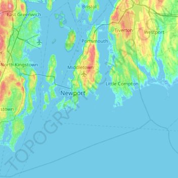
Name: Topografische Karte Newport County, Höhe, Relief.
Ort: Newport County, Rhode Island, United States (41.30736 -71.50944 41.69050 -71.08857)
Durchschnittliche Höhe: 14 m
Minimale Höhe: -7 m
Maximale Höhe: 130 m
Spenden
Rüste dich für dein nächstes Abenteuer:
Als Amazon-Partner verdient diese Seite an qualifizierten Käufen, ohne dass Ihnen zusätzliche Kosten entstehen.
Andere topografische Karten
Klicken Sie auf eine Karte, um ihre Topografie, ihre Höhe und ihr Relief anzuzeigen.
Spenden
Rüste dich für dein nächstes Abenteuer:
Als Amazon-Partner verdient diese Seite an qualifizierten Käufen, ohne dass Ihnen zusätzliche Kosten entstehen.
Spenden
Rüste dich für dein nächstes Abenteuer:
Als Amazon-Partner verdient diese Seite an qualifizierten Käufen, ohne dass Ihnen zusätzliche Kosten entstehen.
Diamond Hill
United States > Rhode Island > Providence County > Cumberland
Durchschnittliche Höhe: 80 m
Diamond Hill Park
United States > Rhode Island > Providence County > Cumberland > Diamond Hill
Durchschnittliche Höhe: 83 m
Rumford
United States > Rhode Island > Providence County > East Providence
Durchschnittliche Höhe: 12 m
Spenden
Rüste dich für dein nächstes Abenteuer:
Als Amazon-Partner verdient diese Seite an qualifizierten Käufen, ohne dass Ihnen zusätzliche Kosten entstehen.
Touisset Wildlife Refuge
United States > Rhode Island > Bristol County > Warren
Durchschnittliche Höhe: 6 m
Mount Pleasant
United States > Rhode Island > Providence County > Providence
Durchschnittliche Höhe: 24 m
Spenden
Rüste dich für dein nächstes Abenteuer:
Als Amazon-Partner verdient diese Seite an qualifizierten Käufen, ohne dass Ihnen zusätzliche Kosten entstehen.
Upper Grinnell Point
United States > Rhode Island > Bristol County > Warren
Durchschnittliche Höhe: 2 m
Jerimoth Hill
United States > Rhode Island > Providence County > Foster
The hill is located on Route 101 in Foster, a half mile from the Connecticut line. To ascend the summit, for which there is a sign, there is a .3-mile (480 m) long trail that has a mere 10-foot (3.0 m) elevation gain. The hill is 812 feet (247 m) high and is located 15 miles (24 km) west of Providence, Rhode…
Durchschnittliche Höhe: 216 m
Spenden
Rüste dich für dein nächstes Abenteuer:
Als Amazon-Partner verdient diese Seite an qualifizierten Käufen, ohne dass Ihnen zusätzliche Kosten entstehen.
Spenden
Rüste dich für dein nächstes Abenteuer:
Als Amazon-Partner verdient diese Seite an qualifizierten Käufen, ohne dass Ihnen zusätzliche Kosten entstehen.
Jerimoth Hill
United States > Rhode Island > Providence County > Foster
The hill is located on Route 101 in Foster, a half mile from the Connecticut line. To ascend the summit, for which there is a sign, there is a 0.3-mile (480 m) long trail that has a mere 10-foot (3.0 m) elevation gain. The hill is 812 feet (247 m) high and is located 15 miles (24 km) west of Providence, Rhode…
Durchschnittliche Höhe: 216 m
Slatersville
United States > Rhode Island > Providence County > North Smithfield
Durchschnittliche Höhe: 87 m
Spenden
Rüste dich für dein nächstes Abenteuer:
Als Amazon-Partner verdient diese Seite an qualifizierten Käufen, ohne dass Ihnen zusätzliche Kosten entstehen.
Wakefield
United States > Rhode Island > South County > South Kingstown > Wakefield
Durchschnittliche Höhe: 23 m
Spenden
Rüste dich für dein nächstes Abenteuer:
Als Amazon-Partner verdient diese Seite an qualifizierten Käufen, ohne dass Ihnen zusätzliche Kosten entstehen.
Wood River Junction
United States > Rhode Island > South County > Richmond
Durchschnittliche Höhe: 26 m
Spenden
Rüste dich für dein nächstes Abenteuer:
Als Amazon-Partner verdient diese Seite an qualifizierten Käufen, ohne dass Ihnen zusätzliche Kosten entstehen.
Spenden
Rüste dich für dein nächstes Abenteuer:
Als Amazon-Partner verdient diese Seite an qualifizierten Käufen, ohne dass Ihnen zusätzliche Kosten entstehen.
Saunderstown
United States > Rhode Island > South County > North Kingstown > Saunderstown
Durchschnittliche Höhe: 14 m
Olneyville
United States > Rhode Island > Providence County > Providence > Olneyville
Durchschnittliche Höhe: 24 m
Spenden
Rüste dich für dein nächstes Abenteuer:
Als Amazon-Partner verdient diese Seite an qualifizierten Käufen, ohne dass Ihnen zusätzliche Kosten entstehen.
Conservation Land (Trails)
United States > Rhode Island > Providence County > Cumberland
Durchschnittliche Höhe: 73 m
Spenden
Rüste dich für dein nächstes Abenteuer:
Als Amazon-Partner verdient diese Seite an qualifizierten Käufen, ohne dass Ihnen zusätzliche Kosten entstehen.