
Spenden
Rüste dich für dein nächstes Abenteuer:
Als Amazon-Partner verdient diese Seite an qualifizierten Käufen, ohne dass Ihnen zusätzliche Kosten entstehen.
Topografische Karte Clawson
Klicken Sie auf die Karte, um die Höhe anzuzeigen.
Spenden
Rüste dich für dein nächstes Abenteuer:
Als Amazon-Partner verdient diese Seite an qualifizierten Käufen, ohne dass Ihnen zusätzliche Kosten entstehen.
Über diese Karte
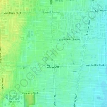
Name: Topografische Karte Clawson, Höhe, Relief.
Ort: Clawson, Oakland County, Michigan, 48017, United States (42.52557 -83.16656 42.54830 -83.12673)
Durchschnittliche Höhe: 206 m
Minimale Höhe: 198 m
Maximale Höhe: 215 m
Spenden
Rüste dich für dein nächstes Abenteuer:
Als Amazon-Partner verdient diese Seite an qualifizierten Käufen, ohne dass Ihnen zusätzliche Kosten entstehen.
Andere topografische Karten
Klicken Sie auf eine Karte, um ihre Topografie, ihre Höhe und ihr Relief anzuzeigen.
Waterford
United States > Michigan > Oakland County > Waterford Township
Durchschnittliche Höhe: 300 m
New Hudson
United States > Michigan > Oakland County > Lyon Charter Township
Durchschnittliche Höhe: 290 m
Spenden
Rüste dich für dein nächstes Abenteuer:
Als Amazon-Partner verdient diese Seite an qualifizierten Käufen, ohne dass Ihnen zusätzliche Kosten entstehen.
Clyde
United States > Michigan > Oakland County > Highland Charter Township
Durchschnittliche Höhe: 315 m
Kensington Metropark
United States > Michigan > Oakland County > Milford Charter Township
Durchschnittliche Höhe: 297 m
Oxbow
United States > Michigan > Oakland County > White Lake Charter Township
Durchschnittliche Höhe: 293 m
Spenden
Rüste dich für dein nächstes Abenteuer:
Als Amazon-Partner verdient diese Seite an qualifizierten Käufen, ohne dass Ihnen zusätzliche Kosten entstehen.
Jossman Acres
United States > Michigan > Oakland County > Springfield Charter Township
Durchschnittliche Höhe: 324 m
Spenden
Rüste dich für dein nächstes Abenteuer:
Als Amazon-Partner verdient diese Seite an qualifizierten Käufen, ohne dass Ihnen zusätzliche Kosten entstehen.
Oxbow
United States > Michigan > Oakland County > White Lake Charter Township
Durchschnittliche Höhe: 293 m
Union Lake
United States > Michigan > Oakland County > White Lake Charter Township
Durchschnittliche Höhe: 290 m
Cranberry Lake
United States > Michigan > Oakland County > White Lake Charter Township
Durchschnittliche Höhe: 295 m
Carpenter Lake Nature Preserve
United States > Michigan > Oakland County > Southfield
Durchschnittliche Höhe: 207 m
Spenden
Rüste dich für dein nächstes Abenteuer:
Als Amazon-Partner verdient diese Seite an qualifizierten Käufen, ohne dass Ihnen zusätzliche Kosten entstehen.
North Farmington
United States > Michigan > Oakland County > Farmington Hills
Durchschnittliche Höhe: 277 m
Dollar Lake
United States > Michigan > Oakland County > Independence Charter Township
Durchschnittliche Höhe: 306 m
Davisburg
United States > Michigan > Oakland County > Springfield Charter Township
Durchschnittliche Höhe: 309 m
Spenden
Rüste dich für dein nächstes Abenteuer:
Als Amazon-Partner verdient diese Seite an qualifizierten Käufen, ohne dass Ihnen zusätzliche Kosten entstehen.
Huron Heights
United States > Michigan > Oakland County > Waterford Charter Township
Durchschnittliche Höhe: 292 m
Spenden
Rüste dich für dein nächstes Abenteuer:
Als Amazon-Partner verdient diese Seite an qualifizierten Käufen, ohne dass Ihnen zusätzliche Kosten entstehen.
Rochester Hills
United States > Michigan > Oakland County > Rochester Hills
Rochester Hills is bordered to the north by Oakland Charter Township along Dutton Road, to the south by the city of Troy along South Boulevard, to the east by Shelby Township in Macomb County along Dequindre Road, and to the west by the city of Auburn Hills along part of Adams Road. Rochester Hills is also…
Durchschnittliche Höhe: 246 m