
Topografische Karte Hardeeville
Interaktive Karte
Klicken Sie auf die Karte, um die Höhe anzuzeigen.
Über diese Karte
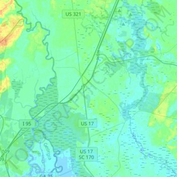
Name: Topografische Karte Hardeeville, Höhe, Relief.
Ort: Hardeeville, Jasper County, South Carolina, United States (32.16501 -81.11998 32.37734 -80.92590)
Durchschnittliche Höhe: 5 m
Minimale Höhe: -4 m
Maximale Höhe: 27 m
The city is located on the Atlantic coastal plain, with very few variations in elevation. The average elevation of the city is approximately 20 feet (6.1 m) above mean sea level. Most of Hardeeville is located within Jasper County, though a small portion of the city crosses into Beaufort County. Much of the city is bordered to the west by the Savannah National Wildlife Refuge, a large-scale nature preserve along the South Carolina and Georgia sides of the Savannah River.
Andere topografische Karten
Klicken Sie auf eine Karte, um ihre Topografie, ihre Höhe und ihr Relief anzuzeigen.
Latitude Margaritaville
United States > South Carolina > Jasper County > Hardeeville
Latitude Margaritaville, Hardeeville, Jasper County, South Carolina, 29927, United States
Durchschnittliche Höhe: 4 m