
Topografische Karte Ankeny
Interaktive Karte
Klicken Sie auf die Karte, um die Höhe anzuzeigen.
Über diese Karte
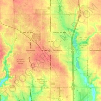
Name: Topografische Karte Ankeny, Höhe, Relief.
Ort: Ankeny, Polk County, Iowa, 50023-3054, United States (41.69187 -93.64038 41.77187 -93.56038)
Durchschnittliche Höhe: 289 m
Minimale Höhe: 255 m
Maximale Höhe: 307 m
Like most of Polk County, Ankeny exists at the bottom area of the Des Moines Lobe, a topographical landscape area, in an area known as the Bemis Advance. The Lobe was formed during the Wisconsin glaciation leaving significant deposits resulting in an area with low relief.