
Spenden
Rüste dich für dein nächstes Abenteuer:
Als Amazon-Partner verdient diese Seite an qualifizierten Käufen, ohne dass Ihnen zusätzliche Kosten entstehen.
Topografische Karte Sioux Center
Klicken Sie auf die Karte, um die Höhe anzuzeigen.
Spenden
Rüste dich für dein nächstes Abenteuer:
Als Amazon-Partner verdient diese Seite an qualifizierten Käufen, ohne dass Ihnen zusätzliche Kosten entstehen.
Sioux Center
Sioux Center is at an elevation of 1,445 feet (440 m) above sea level. It lies near the north-to-south ridge, or spine, of western Iowa. The eastern side of Sioux Center drains to the Floyd River. The western side drains to the Big Sioux River. This "divide" is profoundly unnoticeable. The area within a ten-mile (16 km) radius of Sioux Center has been divided into sections of one square mile each. The gravel and paved roads marking the sections do not swerve or contour for the slight hills or valleys.
Spenden
Rüste dich für dein nächstes Abenteuer:
Als Amazon-Partner verdient diese Seite an qualifizierten Käufen, ohne dass Ihnen zusätzliche Kosten entstehen.
Über diese Karte
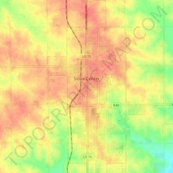
Name: Topografische Karte Sioux Center, Höhe, Relief.
Ort: Sioux Center, Sioux County, Iowa, 51250, United States (43.04430 -96.19566 43.10895 -96.14569)
Durchschnittliche Höhe: 433 m
Minimale Höhe: 398 m
Maximale Höhe: 453 m
Spenden
Rüste dich für dein nächstes Abenteuer:
Als Amazon-Partner verdient diese Seite an qualifizierten Käufen, ohne dass Ihnen zusätzliche Kosten entstehen.
Andere topografische Karten
Klicken Sie auf eine Karte, um ihre Topografie, ihre Höhe und ihr Relief anzuzeigen.
Chatsworth
United States > Iowa > Sioux County > Chatsworth > Chatsworth
Durchschnittliche Höhe: 359 m