
Spenden
Rüste dich für dein nächstes Abenteuer:
Als Amazon-Partner verdient diese Seite an qualifizierten Käufen, ohne dass Ihnen zusätzliche Kosten entstehen.
Topografische Karte Deer Park
Klicken Sie auf die Karte, um die Höhe anzuzeigen.
Spenden
Rüste dich für dein nächstes Abenteuer:
Als Amazon-Partner verdient diese Seite an qualifizierten Käufen, ohne dass Ihnen zusätzliche Kosten entstehen.
Deer Park
Deer Park is located at 47°57′25″N 117°28′13″W / 47.95694°N 117.47028°W / 47.95694; -117.47028 (47.956922, -117.470230), at an elevation of 2,123 feet (647 m) above sea level.
Spenden
Rüste dich für dein nächstes Abenteuer:
Als Amazon-Partner verdient diese Seite an qualifizierten Käufen, ohne dass Ihnen zusätzliche Kosten entstehen.
Über diese Karte
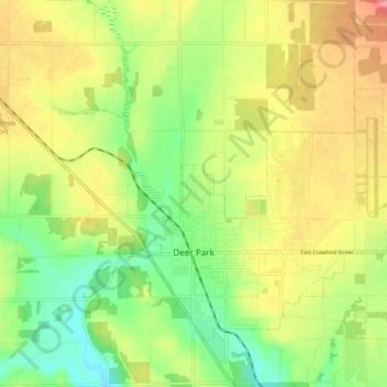
Name: Topografische Karte Deer Park, Höhe, Relief.
Durchschnittliche Höhe: 658 m
Minimale Höhe: 623 m
Maximale Höhe: 695 m
Spenden
Rüste dich für dein nächstes Abenteuer:
Als Amazon-Partner verdient diese Seite an qualifizierten Käufen, ohne dass Ihnen zusätzliche Kosten entstehen.
Andere topografische Karten
Klicken Sie auf eine Karte, um ihre Topografie, ihre Höhe und ihr Relief anzuzeigen.
Mica Peak
United States > Washington > Spokane County
Mica Peak is the name of two separate mountain summits in the United States located approximately 5.49 miles (9 km) apart; one in Spokane County, Washington and the other in Kootenai County, Idaho. The two peaks are located along the same ridge, which separates the Spokane Valley and Rathdrum Prairie from the…
Durchschnittliche Höhe: 1’311 m
Spenden
Rüste dich für dein nächstes Abenteuer:
Als Amazon-Partner verdient diese Seite an qualifizierten Käufen, ohne dass Ihnen zusätzliche Kosten entstehen.
Spenden
Rüste dich für dein nächstes Abenteuer:
Als Amazon-Partner verdient diese Seite an qualifizierten Käufen, ohne dass Ihnen zusätzliche Kosten entstehen.
Spenden
Rüste dich für dein nächstes Abenteuer:
Als Amazon-Partner verdient diese Seite an qualifizierten Käufen, ohne dass Ihnen zusätzliche Kosten entstehen.
Spenden
Rüste dich für dein nächstes Abenteuer:
Als Amazon-Partner verdient diese Seite an qualifizierten Käufen, ohne dass Ihnen zusätzliche Kosten entstehen.
Mica Peak
United States > Washington > Spokane County
Mica Peak is the name of two separate mountain summits in the United States located approximately 5.49 miles (9 km) apart; one in Spokane County, Washington and the other in Kootenai County, Idaho. The two peaks are located along the same ridge, which separates the Spokane Valley and Rathdrum Prairie from the…
Durchschnittliche Höhe: 1’311 m
East Spokane
United States > Washington > Spokane County > Spokane Valley > East Spokane
Durchschnittliche Höhe: 625 m
Spenden
Rüste dich für dein nächstes Abenteuer:
Als Amazon-Partner verdient diese Seite an qualifizierten Käufen, ohne dass Ihnen zusätzliche Kosten entstehen.