
Topografische Karte Oneida County
Interaktive Karte
Klicken Sie auf die Karte, um die Höhe anzuzeigen.
Über diese Karte
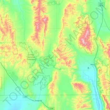
Name: Topografische Karte Oneida County, Höhe, Relief.
Ort: Oneida County, Idaho, United States (41.99724 -113.00008 42.50306 -112.07027)
Durchschnittliche Höhe: 1’678 m
Minimale Höhe: 1’325 m
Maximale Höhe: 2’747 m
Oxford Peak is the highest point in the county at 9,285 ft (2830.2 m) above sea level. Alternating valleys and ridges of mountains or hills typify the topography, with grassland and sagebrush covering most areas. The Curlew National Grassland lies within the county.
Andere topografische Karten
Klicken Sie auf eine Karte, um ihre Topografie, ihre Höhe und ihr Relief anzuzeigen.
Malad Summit
United States > Idaho > Oneida County
Malad Summit, Oneida County, Idaho, United States
Durchschnittliche Höhe: 1’715 m