
Topografische Karte Montana City
Interaktive Karte
Klicken Sie auf die Karte, um die Höhe anzuzeigen.
Über diese Karte
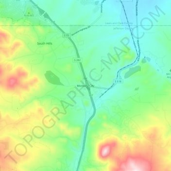
Name: Topografische Karte Montana City, Höhe, Relief.
Durchschnittliche Höhe: 1’341 m
Minimale Höhe: 1’189 m
Maximale Höhe: 1’664 m
Andere topografische Karten
Klicken Sie auf eine Karte, um ihre Topografie, ihre Höhe und ihr Relief anzuzeigen.
Clancy
United States > Montana > Jefferson County
Clancy, Jefferson County, Montana, 59638, United States
Durchschnittliche Höhe: 1’370 m
Rice Motel and Trailer Court
United States > Montana > Jefferson County > Whitehall
Rice Motel and Trailer Court, Whitehall, Jefferson County, Montana, United States
Durchschnittliche Höhe: 1’338 m
Welch
United States > Montana > Jefferson County
Welch, Jefferson County, Montana, United States
Durchschnittliche Höhe: 1’710 m
Boulder River
United States > Montana > Jefferson County > Boulder
Boulder River, Boulder, Jefferson County, Montana, 59631, United States
Durchschnittliche Höhe: 1’966 m
Mount Pisgah
United States > Montana > Jefferson County
Mount Pisgah, Jefferson County, Montana, United States
Durchschnittliche Höhe: 2’265 m
Ringing Rocks
United States > Montana > Jefferson County
Ringing Rocks, Jefferson County, Montana, United States
Durchschnittliche Höhe: 1’702 m
Whitehall
United States > Montana > Jefferson County
Whitehall, Jefferson County, Montana, United States
Durchschnittliche Höhe: 1’336 m