
Topografische Karte Grand Prairie
Interaktive Karte
Klicken Sie auf die Karte, um die Höhe anzuzeigen.
Über diese Karte
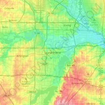
Name: Topografische Karte Grand Prairie, Höhe, Relief.
Ort: Grand Prairie, Dallas County, Texas, 75051, United States (32.58596 -97.15778 32.90596 -96.83778)
Durchschnittliche Höhe: 170 m
Minimale Höhe: 120 m
Maximale Höhe: 262 m
Andere topografische Karten
Klicken Sie auf eine Karte, um ihre Topografie, ihre Höhe und ihr Relief anzuzeigen.
Westchester Valley
United States > Texas > Dallas County > Grand Prairie
Westchester Valley, Grand Prairie, Dallas County, Texas, 75054, United States
Durchschnittliche Höhe: 158 m
Joe Pool Lake
United States > Texas > Dallas County > Grand Prairie
Joe Pool Lake, Grand Prairie, Dallas County, Texas, 75054, United States
Durchschnittliche Höhe: 186 m
South Westchester Meadows
United States > Texas > Dallas County > Grand Prairie
South Westchester Meadows, Grand Prairie, Dallas County, Texas, 75052, United States
Durchschnittliche Höhe: 156 m
Shady Grove
United States > Texas > Dallas County > Grand Prairie
Shady Grove, Grand Prairie, Dallas County, Texas, 75050, United States
Durchschnittliche Höhe: 146 m
South Westchester Meadow
United States > Texas > Dallas County > Grand Prairie
South Westchester Meadow, Grand Prairie, Dallas County, Texas, 75052, United States
Durchschnittliche Höhe: 158 m
Lakeview
United States > Texas > Dallas County > Grand Prairie
Lakeview, Grand Prairie, Dallas County, Texas, 75051, United States
Durchschnittliche Höhe: 149 m