
Topografische Karte Aldenham
Klicken Sie auf die Karte, um die Höhe anzuzeigen.
Über diese Karte
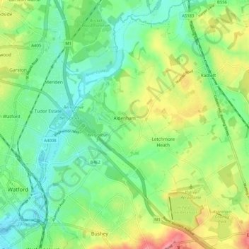
Name: Topografische Karte Aldenham, Höhe, Relief.
Durchschnittliche Höhe: 82 m
Minimale Höhe: 52 m
Maximale Höhe: 136 m
Andere topografische Karten
Klicken Sie auf eine Karte, um ihre Topografie, ihre Höhe und ihr Relief anzuzeigen.
Elstree
United Kingdom > England > Hertfordshire > Hertsmere
In 1723, topographer John Norden noted in his book Speculum Britanniae, that in the county of Hartfordshire [sic] was one "Elstre or Eglestre". In an earlier edition, he writes.
Durchschnittliche Höhe: 105 m
Well End
United Kingdom > England > Hertfordshire > Hertsmere > Borehamwood > Shenley
Durchschnittliche Höhe: 108 m
Bushey
United Kingdom > England > Hertfordshire > Hertsmere
Bushey is a town in the Hertsmere borough of Hertfordshire in the East of England. It had a population of 25,328 in the 2011 census, rising to 28,416 in the 2021 census, an increase of 12.19%. This makes Bushey the second most populated town in Hertsmere. Bushey Heath is a large neighbourhood south east of…
Durchschnittliche Höhe: 88 m
Bentley Heath
United Kingdom > England > Hertfordshire > Hertsmere > Potters Bar
Durchschnittliche Höhe: 105 m
Merry Hill
United Kingdom > England > Hertfordshire > Hertsmere > Bushey Heath > Merry Hill
Durchschnittliche Höhe: 98 m
Bushey
United Kingdom > England > Hertfordshire > Hertsmere
Bushey is a town in the Hertsmere borough of Hertfordshire in the East of England. It had a population of 25,328 in the 2011 census, rising to 28,416 in the 2021 census, an increase of 12.19%. This makes Bushey the second most populated town in Hertsmere. Bushey Heath is a large neighbourhood south east of…
Durchschnittliche Höhe: 88 m
Patchetts Green
United Kingdom > England > Hertfordshire > Hertsmere > Aldenham
Durchschnittliche Höhe: 83 m
Elstree
United Kingdom > England > Hertfordshire > Hertsmere
In 1723, topographer John Norden noted in his book Speculum Britanniae, that in the county of Hartfordshire [sic] was one "Elstre or Eglestre". In an earlier edition, he writes.
Durchschnittliche Höhe: 105 m