
Spenden
Rüste dich für dein nächstes Abenteuer:
Als Amazon-Partner verdient diese Seite an qualifizierten Käufen, ohne dass Ihnen zusätzliche Kosten entstehen.
Topografische Karte Monroe
Klicken Sie auf die Karte, um die Höhe anzuzeigen.
Spenden
Rüste dich für dein nächstes Abenteuer:
Als Amazon-Partner verdient diese Seite an qualifizierten Käufen, ohne dass Ihnen zusätzliche Kosten entstehen.
Monroe
The city lies at the eastern end of the Snohomish River floodplain, with elevations that range from 40 to 210 feet (12 to 64 m). The south and east edges of the city along the Skykomish River are within a 100-year flood hazard zone and also include habitats for migratory birds and game animals. The residential neighborhoods of Monroe lie within the watersheds of French Creek and Woods Creek, which both drain into the Skykomish River before its confluence with the Snoqualmie and Snohomish rivers. The surrounding area includes hills and plateaus that were formed from glacial till and gravel deposits from the Skykomish River. Monroe also sits on a local fault line that produced a pair of minor earthquakes on July 12, 2019, that were felt as far as Seattle and Vancouver without causing damage.
Spenden
Rüste dich für dein nächstes Abenteuer:
Als Amazon-Partner verdient diese Seite an qualifizierten Käufen, ohne dass Ihnen zusätzliche Kosten entstehen.
Über diese Karte
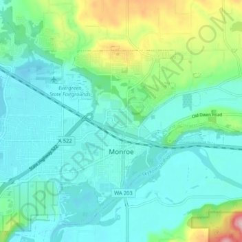
Name: Topografische Karte Monroe, Höhe, Relief.
Ort: Monroe, Snohomish County, Washington, 98272, United States (47.83759 -122.01268 47.88630 -121.93306)
Durchschnittliche Höhe: 49 m
Minimale Höhe: 3 m
Maximale Höhe: 211 m
Spenden
Rüste dich für dein nächstes Abenteuer:
Als Amazon-Partner verdient diese Seite an qualifizierten Käufen, ohne dass Ihnen zusätzliche Kosten entstehen.
Andere topografische Karten
Klicken Sie auf eine Karte, um ihre Topografie, ihre Höhe und ihr Relief anzuzeigen.
Northwest Snohomish
United States > Washington > Snohomish County > Snohomish
Durchschnittliche Höhe: 52 m
Spenden
Rüste dich für dein nächstes Abenteuer:
Als Amazon-Partner verdient diese Seite an qualifizierten Käufen, ohne dass Ihnen zusätzliche Kosten entstehen.
Glacier Peak
United States > Washington > Snohomish County
Despite its elevation of 10,541 feet (3,213 m), Glacier Peak is a small stratovolcano. Its relatively high summit is a consequence of its location atop a high ridge, but its volcanic portion extends only 1,600–3,200 feet (500–1,000 m) above the underlying ridge. Another Cascade Arc volcano with similar…
Durchschnittliche Höhe: 2’656 m
Spenden
Rüste dich für dein nächstes Abenteuer:
Als Amazon-Partner verdient diese Seite an qualifizierten Käufen, ohne dass Ihnen zusätzliche Kosten entstehen.
Bridal Veil Falls-Lower East Cascade
United States > Washington > Snohomish County
Durchschnittliche Höhe: 621 m
Spenden
Rüste dich für dein nächstes Abenteuer:
Als Amazon-Partner verdient diese Seite an qualifizierten Käufen, ohne dass Ihnen zusätzliche Kosten entstehen.
Whitehorse Mountain
United States > Washington > Snohomish County
Whitehorse Mountain is a peak near the western edge of the North Cascades in Washington state. It is located just southwest of the Sauk River Valley town of Darrington, near the northern boundary of Boulder River Wilderness in Mount Baker-Snoqualmie National Forest. While not of particularly high absolute…
Durchschnittliche Höhe: 1’430 m
Lynnwood
United States > Washington > Snohomish County > Lynnwood > Lynnwood
Durchschnittliche Höhe: 112 m
Spenden
Rüste dich für dein nächstes Abenteuer:
Als Amazon-Partner verdient diese Seite an qualifizierten Käufen, ohne dass Ihnen zusätzliche Kosten entstehen.
Mill Creek
United States > Washington > Snohomish County > Mill Creek > Mill Creek
Durchschnittliche Höhe: 129 m
Spenden
Rüste dich für dein nächstes Abenteuer:
Als Amazon-Partner verdient diese Seite an qualifizierten Käufen, ohne dass Ihnen zusätzliche Kosten entstehen.