
Spenden
Rüste dich für dein nächstes Abenteuer:
Als Amazon-Partner verdient diese Seite an qualifizierten Käufen, ohne dass Ihnen zusätzliche Kosten entstehen.
Topografische Karte Salawagan
Klicken Sie auf die Karte, um die Höhe anzuzeigen.
Spenden
Rüste dich für dein nächstes Abenteuer:
Als Amazon-Partner verdient diese Seite an qualifizierten Käufen, ohne dass Ihnen zusätzliche Kosten entstehen.
Über diese Karte
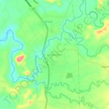
Name: Topografische Karte Salawagan, Höhe, Relief.
Ort: Salawagan, Bukidnon, Northern Mindanao, 8715, Philippines (7.68413 125.09590 7.72413 125.13590)
Durchschnittliche Höhe: 281 m
Minimale Höhe: 234 m
Maximale Höhe: 367 m
Spenden
Rüste dich für dein nächstes Abenteuer:
Als Amazon-Partner verdient diese Seite an qualifizierten Käufen, ohne dass Ihnen zusätzliche Kosten entstehen.
Andere topografische Karten
Klicken Sie auf eine Karte, um ihre Topografie, ihre Höhe und ihr Relief anzuzeigen.
Impasugong
Impasugong is cool and moist throughout the year due to its high elevation ranging from 500 metres (1,600 ft) to more than 1,000 metres (3,300 ft) above sea level. It is a typhoon-free area ideal for the production of high-value crops. Average temperature ranges from 16 to 31 °C (61 to 88 °F) throughout the…
Durchschnittliche Höhe: 903 m
Lake Apo
Philippines > Bukidnon > Valencia
Lake Apo is a crater lake in Barangay Guinoyoran in the city of Valencia in Bukidnon province in the Philippines. It is located in a hilly area about 640 metres (2,100 ft) in elevation, about 11 kilometres (6.8 mi) WSW of the city poblacion (town center). Lake Apo was awarded the cleanest inland body of water…
Durchschnittliche Höhe: 643 m
Spenden
Rüste dich für dein nächstes Abenteuer:
Als Amazon-Partner verdient diese Seite an qualifizierten Käufen, ohne dass Ihnen zusätzliche Kosten entstehen.
Spenden
Rüste dich für dein nächstes Abenteuer:
Als Amazon-Partner verdient diese Seite an qualifizierten Käufen, ohne dass Ihnen zusätzliche Kosten entstehen.
Cabanglasan
The major part of the municipality is classified under slope class 8 to 15 per cent. Where such areas are found, it is contiguous to level areas, identified as water retaining areas potentially suited to intensive palay production. Along its North, East and South boundaries are slope class 30% and above, hilly…
Durchschnittliche Höhe: 605 m
Kibawe
Kibawe is a rich land at the center of Mindanao, located in southern Bukidnon. It is bounded in the north by the municipality of Dangcagan, on the south by the municipality of Damulog, on the east by the municipality of Magpet, North Cotabato, and on the west by the municipality of Kadingilan with Muleta River…
Durchschnittliche Höhe: 267 m
Spenden
Rüste dich für dein nächstes Abenteuer:
Als Amazon-Partner verdient diese Seite an qualifizierten Käufen, ohne dass Ihnen zusätzliche Kosten entstehen.
Dangcagan
It has a fertile soil ranging from clay to sandy loam. Its topography is 70% flat and 30% rolling, which is suitable for agricultural crops such as corn, rice and other commercial crops like coconut, coffee, cacao, rubber, banana and sugar cane.
Durchschnittliche Höhe: 322 m
Spenden
Rüste dich für dein nächstes Abenteuer:
Als Amazon-Partner verdient diese Seite an qualifizierten Käufen, ohne dass Ihnen zusätzliche Kosten entstehen.