
Spenden
Rüste dich für dein nächstes Abenteuer:
Als Amazon-Partner verdient diese Seite an qualifizierten Käufen, ohne dass Ihnen zusätzliche Kosten entstehen.
Topografische Karte Beeley Moor
Klicken Sie auf die Karte, um die Höhe anzuzeigen.
Spenden
Rüste dich für dein nächstes Abenteuer:
Als Amazon-Partner verdient diese Seite an qualifizierten Käufen, ohne dass Ihnen zusätzliche Kosten entstehen.
Über diese Karte
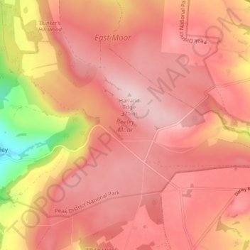
Name: Topografische Karte Beeley Moor, Höhe, Relief.
Durchschnittliche Höhe: 296 m
Minimale Höhe: 116 m
Maximale Höhe: 368 m
Spenden
Rüste dich für dein nächstes Abenteuer:
Als Amazon-Partner verdient diese Seite an qualifizierten Käufen, ohne dass Ihnen zusätzliche Kosten entstehen.
Andere topografische Karten
Klicken Sie auf eine Karte, um ihre Topografie, ihre Höhe und ihr Relief anzuzeigen.
Hallam Moors
United Kingdom > England > Derbyshire > Derbyshire Dales > Hathersage
Durchschnittliche Höhe: 368 m
Spenden
Rüste dich für dein nächstes Abenteuer:
Als Amazon-Partner verdient diese Seite an qualifizierten Käufen, ohne dass Ihnen zusätzliche Kosten entstehen.
Slaley
United Kingdom > England > Derbyshire > Derbyshire Dales > Matlock > Bonsall CP
Durchschnittliche Höhe: 263 m
Spenden
Rüste dich für dein nächstes Abenteuer:
Als Amazon-Partner verdient diese Seite an qualifizierten Käufen, ohne dass Ihnen zusätzliche Kosten entstehen.
Bonsall CP
United Kingdom > England > Derbyshire > Derbyshire Dales > Matlock
Durchschnittliche Höhe: 225 m
Haddon Hall
United Kingdom > England > Derbyshire > Derbyshire Dales > Alport
Durchschnittliche Höhe: 158 m
Spenden
Rüste dich für dein nächstes Abenteuer:
Als Amazon-Partner verdient diese Seite an qualifizierten Käufen, ohne dass Ihnen zusätzliche Kosten entstehen.
Bolehill
United Kingdom > England > Derbyshire > Derbyshire Dales > Wirksworth CP
Durchschnittliche Höhe: 220 m
Spenden
Rüste dich für dein nächstes Abenteuer:
Als Amazon-Partner verdient diese Seite an qualifizierten Käufen, ohne dass Ihnen zusätzliche Kosten entstehen.
Bakewell CP
United Kingdom > England > Derbyshire > Derbyshire Dales
The Manchester, Buxton, Matlock and Midlands Junction Railway opened Bakewell railway station in 1862, then became part of the Midland Railway and later of the LMS main line from London to Manchester. John Ruskin objected to what he saw as desecration of the Derbyshire countryside and to the fact that "a…
Durchschnittliche Höhe: 194 m
Hulland Ward CP
United Kingdom > England > Derbyshire > Derbyshire Dales
Durchschnittliche Höhe: 169 m
Hathersage
United Kingdom > England > Derbyshire > Derbyshire Dales
The Fat Boys Stanage Struggle is a popular local fell race that starts in Hathersage—altitude 91 metres (299 ft)—and routes up to and along Stanage Edge to High Neb—458 metres (1,503 ft)—before returning to the village 367 metres (1,204 ft) below.
Durchschnittliche Höhe: 311 m
Spenden
Rüste dich für dein nächstes Abenteuer:
Als Amazon-Partner verdient diese Seite an qualifizierten Käufen, ohne dass Ihnen zusätzliche Kosten entstehen.
Great Longstone CP
United Kingdom > England > Derbyshire > Derbyshire Dales
Durchschnittliche Höhe: 263 m
Ashbourne CP
United Kingdom > England > Derbyshire > Derbyshire Dales
Ashbourne lies at 53°01′N 01°44′W / 53.017°N 1.733°W / 53.017; -1.733. Ashbourne Green and Sturston are hamlets close by. Henmore Brook, a tributary of the River Dove, flows through the middle of the town. It has an elevation of 400 feet (122 m).
Durchschnittliche Höhe: 147 m
Spenden
Rüste dich für dein nächstes Abenteuer:
Als Amazon-Partner verdient diese Seite an qualifizierten Käufen, ohne dass Ihnen zusätzliche Kosten entstehen.
Tideswell CP
United Kingdom > England > Derbyshire > Derbyshire Dales
Tideswell is a village and civil parish in the Peak District of Derbyshire, England. It lies 6 miles (9.7 km) east of Buxton on the B6049, in a wide valley on a limestone plateau, at an altitude of 1,000 feet (300 m) above sea level, and is within the District of Derbyshire Dales. The population (including…
Durchschnittliche Höhe: 321 m
Stoney Middleton CP
United Kingdom > England > Derbyshire > Derbyshire Dales
Durchschnittliche Höhe: 232 m
Two Dales
United Kingdom > England > Derbyshire > Derbyshire Dales > Darley Dale CP > Darley Hillside
Durchschnittliche Höhe: 189 m
Spenden
Rüste dich für dein nächstes Abenteuer:
Als Amazon-Partner verdient diese Seite an qualifizierten Käufen, ohne dass Ihnen zusätzliche Kosten entstehen.
Starkholmes
United Kingdom > England > Derbyshire > Derbyshire Dales > Matlock
Durchschnittliche Höhe: 175 m
Spenden
Rüste dich für dein nächstes Abenteuer:
Als Amazon-Partner verdient diese Seite an qualifizierten Käufen, ohne dass Ihnen zusätzliche Kosten entstehen.
Darley Dale
United Kingdom > England > Derbyshire > Derbyshire Dales > Darley Hillside
Durchschnittliche Höhe: 206 m
Spenden
Rüste dich für dein nächstes Abenteuer:
Als Amazon-Partner verdient diese Seite an qualifizierten Käufen, ohne dass Ihnen zusätzliche Kosten entstehen.
Little Longstone CP
United Kingdom > England > Derbyshire > Derbyshire Dales
Durchschnittliche Höhe: 262 m
Cressbrook Dale
United Kingdom > England > Derbyshire > Derbyshire Dales > Litton CP > Litton Mill
Durchschnittliche Höhe: 286 m
Spenden
Rüste dich für dein nächstes Abenteuer:
Als Amazon-Partner verdient diese Seite an qualifizierten Käufen, ohne dass Ihnen zusätzliche Kosten entstehen.
Stanton-in-Peak
United Kingdom > England > Derbyshire > Derbyshire Dales
Durchschnittliche Höhe: 175 m
Nether Haddon CP
United Kingdom > England > Derbyshire > Derbyshire Dales
The name "Haddon" means "Heath Hill", the "Nether" referring to being below "Over Haddon". Elevations reach 211 m above Ordnance Datum, just above headsprings in the north. In the east, before flowing into Rowsley, the Wye is at 106 m, which is similar to the Hall at the centre of the civil parish. To the…
Durchschnittliche Höhe: 170 m
Marston Montgomery CP
United Kingdom > England > Derbyshire > Derbyshire Dales
Durchschnittliche Höhe: 132 m
Spenden
Rüste dich für dein nächstes Abenteuer:
Als Amazon-Partner verdient diese Seite an qualifizierten Käufen, ohne dass Ihnen zusätzliche Kosten entstehen.
Spenden
Rüste dich für dein nächstes Abenteuer:
Als Amazon-Partner verdient diese Seite an qualifizierten Käufen, ohne dass Ihnen zusätzliche Kosten entstehen.
Hathersage Booths
United Kingdom > England > Derbyshire > Derbyshire Dales > Hathersage
Durchschnittliche Höhe: 260 m
Spenden
Rüste dich für dein nächstes Abenteuer:
Als Amazon-Partner verdient diese Seite an qualifizierten Käufen, ohne dass Ihnen zusätzliche Kosten entstehen.
Matlock Bath CP
United Kingdom > England > Derbyshire > Derbyshire Dales
Durchschnittliche Höhe: 187 m
Blackwell in the Peak CP
United Kingdom > England > Derbyshire > Derbyshire Dales
Durchschnittliche Höhe: 331 m
Spenden
Rüste dich für dein nächstes Abenteuer:
Als Amazon-Partner verdient diese Seite an qualifizierten Käufen, ohne dass Ihnen zusätzliche Kosten entstehen.
Tansley CP
United Kingdom > England > Derbyshire > Derbyshire Dales > Matlock
Durchschnittliche Höhe: 219 m
Carsington Water
United Kingdom > England > Derbyshire > Derbyshire Dales
Durchschnittliche Höhe: 216 m
Darley Hillside
United Kingdom > England > Derbyshire > Derbyshire Dales
Durchschnittliche Höhe: 187 m
Spenden
Rüste dich für dein nächstes Abenteuer:
Als Amazon-Partner verdient diese Seite an qualifizierten Käufen, ohne dass Ihnen zusätzliche Kosten entstehen.
Housley
United Kingdom > England > Derbyshire > Derbyshire Dales > Eyam CP
Durchschnittliche Höhe: 303 m
Hungry Bentley CP
United Kingdom > England > Derbyshire > Derbyshire Dales
Durchschnittliche Höhe: 131 m
Spenden
Rüste dich für dein nächstes Abenteuer:
Als Amazon-Partner verdient diese Seite an qualifizierten Käufen, ohne dass Ihnen zusätzliche Kosten entstehen.
Spenden
Rüste dich für dein nächstes Abenteuer:
Als Amazon-Partner verdient diese Seite an qualifizierten Käufen, ohne dass Ihnen zusätzliche Kosten entstehen.
Monsal Head
United Kingdom > England > Derbyshire > Derbyshire Dales > Cressbrook > Monsal Head
Durchschnittliche Höhe: 231 m
Spenden
Rüste dich für dein nächstes Abenteuer:
Als Amazon-Partner verdient diese Seite an qualifizierten Käufen, ohne dass Ihnen zusätzliche Kosten entstehen.
Spenden
Rüste dich für dein nächstes Abenteuer:
Als Amazon-Partner verdient diese Seite an qualifizierten Käufen, ohne dass Ihnen zusätzliche Kosten entstehen.
Ashford in the Water CP
United Kingdom > England > Derbyshire > Derbyshire Dales
Durchschnittliche Höhe: 227 m
Spenden
Rüste dich für dein nächstes Abenteuer:
Als Amazon-Partner verdient diese Seite an qualifizierten Käufen, ohne dass Ihnen zusätzliche Kosten entstehen.
Breamfield
United Kingdom > England > Derbyshire > Derbyshire Dales > Wirksworth CP > Breamfield
Durchschnittliche Höhe: 213 m
Coplow Dale
United Kingdom > England > Derbyshire > Derbyshire Dales > Little Hucklow
Durchschnittliche Höhe: 333 m
Spenden
Rüste dich für dein nächstes Abenteuer:
Als Amazon-Partner verdient diese Seite an qualifizierten Käufen, ohne dass Ihnen zusätzliche Kosten entstehen.
Elton CP
United Kingdom > England > Derbyshire > Derbyshire Dales
At 271 metres (889 ft) above sea level, Elton is less sheltered from the wind than settlements at lower elevation, and it therefore has a reputation for being cold. The highest point on Elton Moor, known as Blake Low, is 330 metres (1,080 ft) above sea level; at this location is Elton Common trig point…
Durchschnittliche Höhe: 268 m
Calver Sough
United Kingdom > England > Derbyshire > Derbyshire Dales > Calver Sough
Durchschnittliche Höhe: 218 m
Spenden
Rüste dich für dein nächstes Abenteuer:
Als Amazon-Partner verdient diese Seite an qualifizierten Käufen, ohne dass Ihnen zusätzliche Kosten entstehen.
Parsley Hay
United Kingdom > England > Derbyshire > Derbyshire Dales > Parsley Hay
Durchschnittliche Höhe: 334 m
Longstone Edge
United Kingdom > England > Derbyshire > Derbyshire Dales > Rowland
Durchschnittliche Höhe: 290 m
Spenden
Rüste dich für dein nächstes Abenteuer:
Als Amazon-Partner verdient diese Seite an qualifizierten Käufen, ohne dass Ihnen zusätzliche Kosten entstehen.
Arbor Low
United Kingdom > England > Derbyshire > Derbyshire Dales > Parsley Hay
Durchschnittliche Höhe: 342 m
Spenden
Rüste dich für dein nächstes Abenteuer:
Als Amazon-Partner verdient diese Seite an qualifizierten Käufen, ohne dass Ihnen zusätzliche Kosten entstehen.
Longcliffe
United Kingdom > England > Derbyshire > Derbyshire Dales > Brassington CP
Durchschnittliche Höhe: 299 m
Winster CP
United Kingdom > England > Derbyshire > Derbyshire Dales
Winster is a village in the English Derbyshire Dales about 5 miles (8 km) from Matlock and 6 miles (10 km) from Bakewell at an altitude of approximately 820 feet (250 m). It was formerly a centre for the lead mining industry. The village lies within the Peak District National Park and The Peak District…
Durchschnittliche Höhe: 274 m
Spenden
Rüste dich für dein nächstes Abenteuer:
Als Amazon-Partner verdient diese Seite an qualifizierten Käufen, ohne dass Ihnen zusätzliche Kosten entstehen.