
Topografische Karte Buffalo Cove
Interaktive Karte
Klicken Sie auf die Karte, um die Höhe anzuzeigen.
Über diese Karte
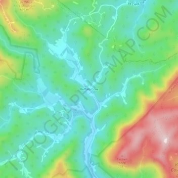
Name: Topografische Karte Buffalo Cove, Höhe, Relief.
Ort: Buffalo Cove, Caldwell County, North Carolina, United States (36.07124 -81.54677 36.11124 -81.50677)
Durchschnittliche Höhe: 529 m
Minimale Höhe: 405 m
Maximale Höhe: 799 m
Andere topografische Karten
Klicken Sie auf eine Karte, um ihre Topografie, ihre Höhe und ihr Relief anzuzeigen.
Lenoir
United States > North Carolina > Caldwell County
Lenoir, Caldwell County, North Carolina, 28645, United States
Durchschnittliche Höhe: 381 m
Patterson
United States > North Carolina > Caldwell County
Patterson, Caldwell County, North Carolina, United States
Durchschnittliche Höhe: 450 m
Collettsville
United States > North Carolina > Caldwell County
Collettsville, Caldwell County, North Carolina, United States
Durchschnittliche Höhe: 378 m
Brown Mountain Beach
United States > North Carolina > Caldwell County
Brown Mountain Beach, Caldwell County, North Carolina, United States
Durchschnittliche Höhe: 423 m
Cedar Rock Estates
United States > North Carolina > Caldwell County > Lenoir
Cedar Rock Estates, Lenoir, Caldwell County, North Carolina, United States
Durchschnittliche Höhe: 441 m
Grassy Knob
United States > North Carolina > Caldwell County > Lenoir
Grassy Knob, Lenoir, Caldwell County, North Carolina, United States
Durchschnittliche Höhe: 412 m
Gamewell
United States > North Carolina > Caldwell County > Gamewell
Gamewell, Caldwell County, North Carolina, United States
Durchschnittliche Höhe: 346 m
Grand View Park
United States > North Carolina > Caldwell County > Lenoir > Grand View Park
Grand View Park, Lenoir, Caldwell County, North Carolina, 8645, United States
Durchschnittliche Höhe: 348 m