
Topografische Karte Dawson Knob
Interaktive Karte
Klicken Sie auf die Karte, um die Höhe anzuzeigen.
Über diese Karte
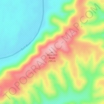
Name: Topografische Karte Dawson Knob, Höhe, Relief.
Ort: Dawson Knob, Bullitt County, Kentucky, United States (37.92113 -85.78668 37.92123 -85.78658)
Durchschnittliche Höhe: 203 m
Minimale Höhe: 128 m
Maximale Höhe: 300 m
Andere topografische Karten
Klicken Sie auf eine Karte, um ihre Topografie, ihre Höhe und ihr Relief anzuzeigen.
Shepherdsville
United States > Kentucky > Bullitt County
Shepherdsville, Bullitt County, Kentucky, United States
Durchschnittliche Höhe: 148 m
Brooks
United States > Kentucky > Bullitt County
Brooks, Bullitt County, Kentucky, 40109, United States
Durchschnittliche Höhe: 189 m
Hillview
United States > Kentucky > Bullitt County
Hillview, Bullitt County, Kentucky, United States
Durchschnittliche Höhe: 162 m
Mount Washington
United States > Kentucky > Bullitt County
Mount Washington, Bullitt County, Kentucky, 40047, United States
Durchschnittliche Höhe: 184 m
Bernheim Forest
United States > Kentucky > Bullitt County
Bernheim Forest, Bullitt County, Kentucky, United States
Durchschnittliche Höhe: 230 m
Salt River
United States > Kentucky > Bullitt County > Shepherdsville
Salt River, Shepherdsville, Bullitt County, Kentucky, 40165, United States
Durchschnittliche Höhe: 140 m
Phelps Knob
United States > Kentucky > Bullitt County
Phelps Knob, Bullitt County, Kentucky, 40165, United States
Durchschnittliche Höhe: 161 m