
Spenden
Rüste dich für dein nächstes Abenteuer:
Als Amazon-Partner verdient diese Seite an qualifizierten Käufen, ohne dass Ihnen zusätzliche Kosten entstehen.
Topografische Karte Lake Hart
Klicken Sie auf die Karte, um die Höhe anzuzeigen.
Spenden
Rüste dich für dein nächstes Abenteuer:
Als Amazon-Partner verdient diese Seite an qualifizierten Käufen, ohne dass Ihnen zusätzliche Kosten entstehen.
Über diese Karte
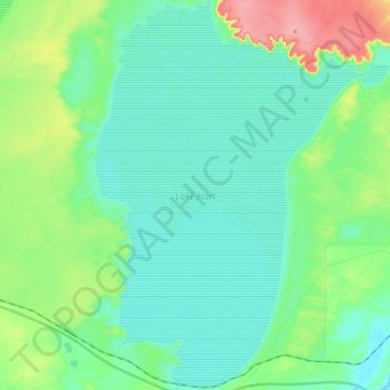
Name: Topografische Karte Lake Hart, Höhe, Relief.
Durchschnittliche Höhe: 115 m
Minimale Höhe: 92 m
Maximale Höhe: 188 m
Spenden
Rüste dich für dein nächstes Abenteuer:
Als Amazon-Partner verdient diese Seite an qualifizierten Käufen, ohne dass Ihnen zusätzliche Kosten entstehen.
Andere topografische Karten
Klicken Sie auf eine Karte, um ihre Topografie, ihre Höhe und ihr Relief anzuzeigen.
Stokes Hill Lookout
Australia > South Australia > Pastoral Unincorporated Area
Durchschnittliche Höhe: 684 m
Spenden
Rüste dich für dein nächstes Abenteuer:
Als Amazon-Partner verdient diese Seite an qualifizierten Käufen, ohne dass Ihnen zusätzliche Kosten entstehen.
Flinders Ranges
Australia > South Australia > Pastoral Unincorporated Area
Durchschnittliche Höhe: 808 m
Bunkers Conservation Reserve
Australia > South Australia > Pastoral Unincorporated Area
Durchschnittliche Höhe: 494 m
Spenden
Rüste dich für dein nächstes Abenteuer:
Als Amazon-Partner verdient diese Seite an qualifizierten Käufen, ohne dass Ihnen zusätzliche Kosten entstehen.
Dullingari
Australia > South Australia > Pastoral Unincorporated Area > Innamincka
Durchschnittliche Höhe: 89 m
Spenden
Rüste dich für dein nächstes Abenteuer:
Als Amazon-Partner verdient diese Seite an qualifizierten Käufen, ohne dass Ihnen zusätzliche Kosten entstehen.
Wilpena Pound
Australia > South Australia > Pastoral Unincorporated Area
Durchschnittliche Höhe: 593 m
Wabma Kadarbu Mound Springs Conservation Park
Australia > South Australia > Pastoral Unincorporated Area
Durchschnittliche Höhe: 18 m
Nullabor Plain
Australia > South Australia > Pastoral Unincorporated Area
One theory is that the whole area was uplifted by crustal movements in the Miocene, and since then, erosion by wind and rain has reduced its thickness. The plain has most likely never had any major defining topographic features, resulting in the extremely flat terrain across the plain today.
Durchschnittliche Höhe: 117 m
Spenden
Rüste dich für dein nächstes Abenteuer:
Als Amazon-Partner verdient diese Seite an qualifizierten Käufen, ohne dass Ihnen zusätzliche Kosten entstehen.
Arkaroola Village
Australia > South Australia > Pastoral Unincorporated Area
Durchschnittliche Höhe: 392 m
Carrapateena Hill
Australia > South Australia > Pastoral Unincorporated Area
Durchschnittliche Höhe: 150 m
Spenden
Rüste dich für dein nächstes Abenteuer:
Als Amazon-Partner verdient diese Seite an qualifizierten Käufen, ohne dass Ihnen zusätzliche Kosten entstehen.
Ikara-Flinders Ranges National Park
Australia > South Australia > Pastoral Unincorporated Area
Durchschnittliche Höhe: 430 m
One Tree Hill
Australia > South Australia > Pastoral Unincorporated Area
Durchschnittliche Höhe: 351 m
Spenden
Rüste dich für dein nächstes Abenteuer:
Als Amazon-Partner verdient diese Seite an qualifizierten Käufen, ohne dass Ihnen zusätzliche Kosten entstehen.
Blinman North
Australia > South Australia > Pastoral Unincorporated Area
Durchschnittliche Höhe: 628 m
Gum Creek Station
Australia > South Australia > Pastoral Unincorporated Area
Durchschnittliche Höhe: 529 m
Spenden
Rüste dich für dein nächstes Abenteuer:
Als Amazon-Partner verdient diese Seite an qualifizierten Käufen, ohne dass Ihnen zusätzliche Kosten entstehen.
Spenden
Rüste dich für dein nächstes Abenteuer:
Als Amazon-Partner verdient diese Seite an qualifizierten Käufen, ohne dass Ihnen zusätzliche Kosten entstehen.
Bollards Lagoon
Australia > South Australia > Pastoral Unincorporated Area
Durchschnittliche Höhe: 70 m
McDouall Peak
Australia > South Australia > Pastoral Unincorporated Area
Durchschnittliche Höhe: 166 m
Spenden
Rüste dich für dein nächstes Abenteuer:
Als Amazon-Partner verdient diese Seite an qualifizierten Käufen, ohne dass Ihnen zusätzliche Kosten entstehen.
Oodnadatta
Australia > South Australia > Pastoral Unincorporated Area
Oodnadatta is a small, remote outback town and locality in the Australian state of South Australia, located 1043 kilometres (648 miles) north-north-west of the state capital of Adelaide by road or 873 km (542 mi) direct, at an altitude of 112 metres (367 feet). The unsealed Oodnadatta Track, an outback road…
Durchschnittliche Höhe: 130 m
Middleback Range
Australia > South Australia > Pastoral Unincorporated Area
Durchschnittliche Höhe: 109 m
Spenden
Rüste dich für dein nächstes Abenteuer:
Als Amazon-Partner verdient diese Seite an qualifizierten Käufen, ohne dass Ihnen zusätzliche Kosten entstehen.
Spenden
Rüste dich für dein nächstes Abenteuer:
Als Amazon-Partner verdient diese Seite an qualifizierten Käufen, ohne dass Ihnen zusätzliche Kosten entstehen.
Lake Eyre Basin
Australia > South Australia > Pastoral Unincorporated Area
Durchschnittliche Höhe: 33 m
Malkumba-Coongie Lakes National Park
Australia > South Australia > Pastoral Unincorporated Area > Innamincka
Durchschnittliche Höhe: 36 m
Spenden
Rüste dich für dein nächstes Abenteuer:
Als Amazon-Partner verdient diese Seite an qualifizierten Käufen, ohne dass Ihnen zusätzliche Kosten entstehen.
Fowlers Bay
Australia > South Australia > Pastoral Unincorporated Area > Fowlers Bay
Durchschnittliche Höhe: 3 m
Spenden
Rüste dich für dein nächstes Abenteuer:
Als Amazon-Partner verdient diese Seite an qualifizierten Käufen, ohne dass Ihnen zusätzliche Kosten entstehen.
Mungerannie
Australia > South Australia > Pastoral Unincorporated Area > Mungerannie
Durchschnittliche Höhe: 59 m
Leigh Creek
Australia > South Australia > Pastoral Unincorporated Area > Leigh Creek
Durchschnittliche Höhe: 267 m
Lyndhurst
Australia > South Australia > Pastoral Unincorporated Area > Lyndhurst
Durchschnittliche Höhe: 133 m
Spenden
Rüste dich für dein nächstes Abenteuer:
Als Amazon-Partner verdient diese Seite an qualifizierten Käufen, ohne dass Ihnen zusätzliche Kosten entstehen.
Mount Goddard
Australia > South Australia > Pastoral Unincorporated Area
Durchschnittliche Höhe: 548 m
Spenden
Rüste dich für dein nächstes Abenteuer:
Als Amazon-Partner verdient diese Seite an qualifizierten Käufen, ohne dass Ihnen zusätzliche Kosten entstehen.
Spenden
Rüste dich für dein nächstes Abenteuer:
Als Amazon-Partner verdient diese Seite an qualifizierten Käufen, ohne dass Ihnen zusätzliche Kosten entstehen.
Lake Acraman
Australia > South Australia > Pastoral Unincorporated Area
Oblique Landsat image of Lake Acraman draped over digital elevation model (10x vertical exaggeration), looking east towards the Flinders Ranges where ejecta has been found; screen capture from NASA World Wind.
Durchschnittliche Höhe: 147 m
Far West Coast Marine Park
Australia > South Australia > Pastoral Unincorporated Area
Durchschnittliche Höhe: 66 m
Ironstone Hill Conservation Park
Australia > South Australia > Pastoral Unincorporated Area
Durchschnittliche Höhe: 196 m
Spenden
Rüste dich für dein nächstes Abenteuer:
Als Amazon-Partner verdient diese Seite an qualifizierten Käufen, ohne dass Ihnen zusätzliche Kosten entstehen.
Nilpena Ediacara National Park
Australia > South Australia > Pastoral Unincorporated Area
Durchschnittliche Höhe: 84 m
Gammon Ranges
Australia > South Australia > Pastoral Unincorporated Area
Durchschnittliche Höhe: 325 m
Spenden
Rüste dich für dein nächstes Abenteuer:
Als Amazon-Partner verdient diese Seite an qualifizierten Käufen, ohne dass Ihnen zusätzliche Kosten entstehen.
Spenden
Rüste dich für dein nächstes Abenteuer:
Als Amazon-Partner verdient diese Seite an qualifizierten Käufen, ohne dass Ihnen zusätzliche Kosten entstehen.
Lake Callabonna
Australia > South Australia > Pastoral Unincorporated Area
Durchschnittliche Höhe: 24 m
Spenden
Rüste dich für dein nächstes Abenteuer:
Als Amazon-Partner verdient diese Seite an qualifizierten Käufen, ohne dass Ihnen zusätzliche Kosten entstehen.
Flinders Ranges
Australia > South Australia > Pastoral Unincorporated Area
Durchschnittliche Höhe: 808 m
Spenden
Rüste dich für dein nächstes Abenteuer:
Als Amazon-Partner verdient diese Seite an qualifizierten Käufen, ohne dass Ihnen zusätzliche Kosten entstehen.