
Spenden
Rüste dich für dein nächstes Abenteuer:
Als Amazon-Partner verdient diese Seite an qualifizierten Käufen, ohne dass Ihnen zusätzliche Kosten entstehen.
Topografische Karte Blakeley
Klicken Sie auf die Karte, um die Höhe anzuzeigen.
Spenden
Rüste dich für dein nächstes Abenteuer:
Als Amazon-Partner verdient diese Seite an qualifizierten Käufen, ohne dass Ihnen zusätzliche Kosten entstehen.
Über diese Karte
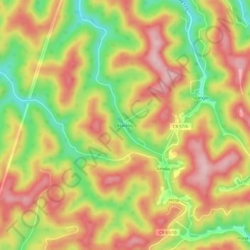
Name: Topografische Karte Blakeley, Höhe, Relief.
Durchschnittliche Höhe: 408 m
Minimale Höhe: 291 m
Maximale Höhe: 501 m
Spenden
Rüste dich für dein nächstes Abenteuer:
Als Amazon-Partner verdient diese Seite an qualifizierten Käufen, ohne dass Ihnen zusätzliche Kosten entstehen.
Andere topografische Karten
Klicken Sie auf eine Karte, um ihre Topografie, ihre Höhe und ihr Relief anzuzeigen.
Charleston
United States > West Virginia > Kanawha County
Charleston has a four-season humid subtropical climate (Köppen Cfa) with continental climate (Dfa) elements. Especially in winter, Charleston's average temperatures are warmer than the rest of the state, due to the city being west of the higher elevations. Spring is the most unpredictable season, and…
Durchschnittliche Höhe: 264 m
Kanawha River
United States > West Virginia > Kanawha County
The Kanawha River lends its name to a major geological section of the Appalachian Highlands physiographic region of the United States called a physiographic region. A physiographic region is a large portion of land that is grouped by several factors. Each region has similar geology, topography, and groups of…
Durchschnittliche Höhe: 280 m
Spenden
Rüste dich für dein nächstes Abenteuer:
Als Amazon-Partner verdient diese Seite an qualifizierten Käufen, ohne dass Ihnen zusätzliche Kosten entstehen.
Charleston
United States > West Virginia > Kanawha County
Charleston has a four-season humid subtropical climate (Köppen Cfa) with continental climate (Dfa) elements. Especially in winter, Charleston's average temperatures are warmer than the rest of the state, due to the city being west of the higher elevations. Spring is the most unpredictable season, and…
Durchschnittliche Höhe: 264 m