
Topografische Karte Albany Forks
Klicken Sie auf die Karte, um die Höhe anzuzeigen.
Über diese Karte
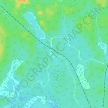
Name: Topografische Karte Albany Forks, Höhe, Relief.
Durchschnittliche Höhe: 324 m
Minimale Höhe: 316 m
Maximale Höhe: 342 m
Andere topografische Karten
Klicken Sie auf eine Karte, um ihre Topografie, ihre Höhe und ihr Relief anzuzeigen.
Montreal River
Canada > Ontario > Algoma District > Unorganized North Algoma
Durchschnittliche Höhe: 360 m
Manitowik Lake
Canada > Ontario > Algoma District > Unorganized North Algoma
Durchschnittliche Höhe: 394 m
Tilley Lakes
Canada > Ontario > Algoma District > Unorganized North Algoma
Durchschnittliche Höhe: 301 m
Lucille Lake;Wood Creek
Canada > Ontario > Algoma District > Unorganized North Algoma
Durchschnittliche Höhe: 441 m
Alpha Lake
Canada > Ontario > Algoma District > Unorganized North Algoma
Durchschnittliche Höhe: 314 m
Daisy Lake
Canada > Ontario > Algoma District > Unorganized North Algoma
Durchschnittliche Höhe: 457 m
Raven Lake
Canada > Ontario > Algoma District > Unorganized North Algoma
Durchschnittliche Höhe: 371 m
Burnt Lake
Canada > Ontario > Algoma District > Unorganized North Algoma
Durchschnittliche Höhe: 444 m
Moccasin Lake
Canada > Ontario > Algoma District > Unorganized North Algoma
Durchschnittliche Höhe: 477 m
Clayton Lake
Canada > Ontario > Algoma District > Unorganized North Algoma
Durchschnittliche Höhe: 381 m
Kabinakagami Lake
Canada > Ontario > Algoma District > Unorganized North Algoma
Durchschnittliche Höhe: 332 m
Seymour Lake
Canada > Ontario > Algoma District > Unorganized North Algoma
Durchschnittliche Höhe: 436 m
Caddy Lake
Canada > Ontario > Algoma District > Unorganized North Algoma
Durchschnittliche Höhe: 424 m
Kirkpatrick Lake
Canada > Ontario > Algoma District > Unorganized North Algoma
Durchschnittliche Höhe: 429 m
Northland Lake
Canada > Ontario > Algoma District > Unorganized North Algoma
Durchschnittliche Höhe: 387 m
Mosambik Lake
Canada > Ontario > Algoma District > Unorganized North Algoma
Durchschnittliche Höhe: 363 m
Goulais River
Canada > Ontario > Algoma District > Unorganized North Algoma
Durchschnittliche Höhe: 362 m
Fire River
Canada > Ontario > Algoma District > Unorganized North Algoma
Durchschnittliche Höhe: 399 m
Kimiwan Creek;Kimiwan Lakes
Canada > Ontario > Algoma District > Unorganized North Algoma
Durchschnittliche Höhe: 442 m
Limerick Lake
Canada > Ontario > Algoma District > Unorganized North Algoma
Durchschnittliche Höhe: 505 m
Mashagama Lake
Canada > Ontario > Algoma District > Unorganized North Algoma
Durchschnittliche Höhe: 458 m
Montreal Island
Canada > Ontario > Algoma District > Unorganized North Algoma
Durchschnittliche Höhe: 190 m
Lanier Lake
Canada > Ontario > Algoma District > Unorganized North Algoma
Durchschnittliche Höhe: 403 m
Kabinakagamisis Lake
Canada > Ontario > Algoma District > Unorganized North Algoma
Durchschnittliche Höhe: 324 m
Chapleau River
Canada > Ontario > Algoma District > Unorganized North Algoma
Durchschnittliche Höhe: 328 m
Esnagi Lake
Canada > Ontario > Algoma District > Unorganized North Algoma
Durchschnittliche Höhe: 391 m
Wakomata Lake
Canada > Ontario > Algoma District > Unorganized North Algoma
Durchschnittliche Höhe: 380 m
Flack Lake
Canada > Ontario > Algoma District > Unorganized North Algoma
Durchschnittliche Höhe: 384 m