
Topografische Karte Haslemere
Klicken Sie auf die Karte, um die Höhe anzuzeigen.
Haslemere
Many of the roads in the area originated as medieval tracks and owing to the local topography, are narrow, twisting and steep. The principal route through Haslemere is the A286, which connects the town with Godalming and Grayswood (to the north) and with Midhurst (to the south). The A287 runs south from Hindhead and passes through the west end of Shottermill, before joining the A286 close to Camelsdale. The main east–west road is the B2131, which links Haslemere to Chiddingfold and Petworth to the east, and to Liphook to the west.
Über diese Karte
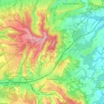
Name: Topografische Karte Haslemere, Höhe, Relief.
Ort: Haslemere, Waverley, Surrey, England, United Kingdom (51.07150 -0.78090 51.13905 -0.67473)
Durchschnittliche Höhe: 150 m
Minimale Höhe: 65 m
Maximale Höhe: 273 m
Andere topografische Karten
Klicken Sie auf eine Karte, um ihre Topografie, ihre Höhe und ihr Relief anzuzeigen.
Winkworth Arboretum
United Kingdom > England > Surrey > Waverley > Hascombe
Durchschnittliche Höhe: 111 m
Rodborough Common
United Kingdom > England > Surrey > Waverley > Cramhurst
Durchschnittliche Höhe: 62 m
Hankley Common
United Kingdom > England > Surrey > Waverley > Thursley > Truxford
Durchschnittliche Höhe: 70 m
Camelsdale
United Kingdom > England > Surrey > Waverley > Haslemere > Shottermill
Durchschnittliche Höhe: 166 m
Lakers Green
United Kingdom > England > Surrey > Waverley > Alfold Crossways
Durchschnittliche Höhe: 55 m
Frensham Great Pond
United Kingdom > England > Surrey > Waverley > Frensham
Durchschnittliche Höhe: 72 m
Rodborough Common
United Kingdom > England > Surrey > Waverley > Cramhurst
Durchschnittliche Höhe: 62 m
Floodplain (seasonal)
United Kingdom > England > Surrey > Waverley > Farnham > Wrecclesham
Durchschnittliche Höhe: 94 m