
Topografische Karte La Meslaie
Interaktive Karte
Klicken Sie auf die Karte, um die Höhe anzuzeigen.
Über diese Karte
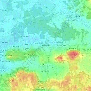
Name: Topografische Karte La Meslaie, Höhe, Relief.
Durchschnittliche Höhe: 51 m
Minimale Höhe: 32 m
Maximale Höhe: 92 m
Andere topografische Karten
Klicken Sie auf eine Karte, um ihre Topografie, ihre Höhe und ihr Relief anzuzeigen.
Le Bourg
France > Centre-Val de Loire > Indre-et-Loire > Beaumont-en-Véron
Le Bourg, Beaumont-en-Véron, Chinon, Indre-et-Loire, Centre-Val de Loire, France métropolitaine, 37420, France
Durchschnittliche Höhe: 44 m
Les Caves aux Fièvres
France > Centre-Val de Loire > Indre-et-Loire > Beaumont-en-Véron
Les Caves aux Fièvres, Beaumont-en-Véron, Chinon, Indre-et-Loire, Centre-Val de Loire, France métropolitaine, 37420, France
Durchschnittliche Höhe: 38 m
Les Baffes
France > Centre-Val de Loire > Indre-et-Loire > Beaumont-en-Véron
Les Baffes, Beaumont-en-Véron, Chinon, Indre-et-Loire, Centre-Val de Loire, France métropolitaine, 37420, France
Durchschnittliche Höhe: 46 m
La Haute Rue
France > Centre-Val de Loire > Indre-et-Loire > Beaumont-en-Véron > La Haute Rue
La Haute Rue, Beaumont-en-Véron, Chinon, Indre-et-Loire, Centre-Val de Loire, France métropolitaine, 37420, France
Durchschnittliche Höhe: 40 m