
Topografische Karte Gençlik Parkı
Interaktive Karte
Klicken Sie auf die Karte, um die Höhe anzuzeigen.
Über diese Karte
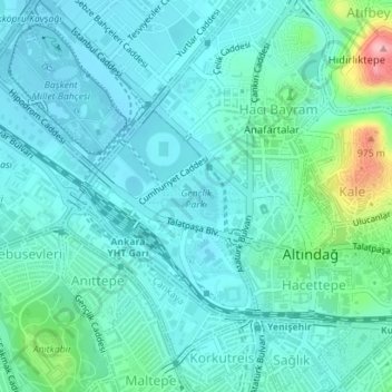
Name: Topografische Karte Gençlik Parkı, Höhe, Relief.
Durchschnittliche Höhe: 870 m
Minimale Höhe: 842 m
Maximale Höhe: 1’000 m
The 27.5 ha (68 acres) park is almost at the center of Ankara. Its altitude is about 850 m (2,790 ft), which makes it one of the lowest points in Ankara. It is surrounded by Ulus Square to the north, the Ankara Opera House (formerly Ankara Exhibition Building) to the east, Selim Sırrı Tarcan Sport Hall and Ankara Central Station to the south and, 19 Mayıs Stadium to the west.
Andere topografische Karten
Klicken Sie auf eine Karte, um ihre Topografie, ihre Höhe und ihr Relief anzuzeigen.