
Spenden
Rüste dich für dein nächstes Abenteuer:
Als Amazon-Partner verdient diese Seite an qualifizierten Käufen, ohne dass Ihnen zusätzliche Kosten entstehen.
Topografische Karte Milton
Klicken Sie auf die Karte, um die Höhe anzuzeigen.
Spenden
Rüste dich für dein nächstes Abenteuer:
Als Amazon-Partner verdient diese Seite an qualifizierten Käufen, ohne dass Ihnen zusätzliche Kosten entstehen.
Milton
Massachusett, the indigenous name for the Great Blue Hill, was the largest of the cluster of hills along the southern coast of Massachusetts Bay. As the second-highest elevation in all of Eastern America directly on the Atlantic coast, it possessed a sacred status in the religion of the Massachusett people. Beyond being a sacred site, the various hills were mined extensively by the indigenous inhabitants due to the abundance of a type of rare stone formed by the volcanic eruption of Massachusett 200 million years ago that was highly favorable for stone tools. These tools were traded among the indigenous people of the Northeast due to the rarity of the stone. This also indicates that the trade networks of the indigenous Northeast were far more expansive than previously thought.
Spenden
Rüste dich für dein nächstes Abenteuer:
Als Amazon-Partner verdient diese Seite an qualifizierten Käufen, ohne dass Ihnen zusätzliche Kosten entstehen.
Über diese Karte
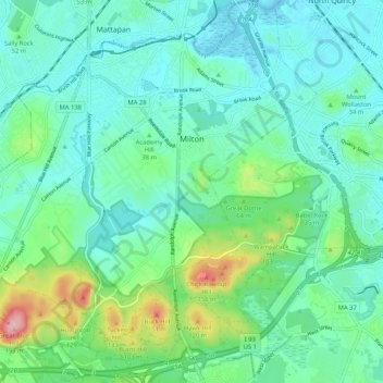
Name: Topografische Karte Milton, Höhe, Relief.
Ort: Milton, Norfolk County, Massachusetts, United States (42.20071 -71.13075 42.27803 -71.03143)
Durchschnittliche Höhe: 41 m
Minimale Höhe: -2 m
Maximale Höhe: 189 m
Spenden
Rüste dich für dein nächstes Abenteuer:
Als Amazon-Partner verdient diese Seite an qualifizierten Käufen, ohne dass Ihnen zusätzliche Kosten entstehen.
Andere topografische Karten
Klicken Sie auf eine Karte, um ihre Topografie, ihre Höhe und ihr Relief anzuzeigen.
East Braintree
United States > Massachusetts > Norfolk County > Braintree
Durchschnittliche Höhe: 22 m
Charles River Village
United States > Massachusetts > Norfolk County > Needham
Durchschnittliche Höhe: 49 m
Weymouth Landing
United States > Massachusetts > Norfolk County > Weymouth
Durchschnittliche Höhe: 21 m
Spenden
Rüste dich für dein nächstes Abenteuer:
Als Amazon-Partner verdient diese Seite an qualifizierten Käufen, ohne dass Ihnen zusätzliche Kosten entstehen.
Spenden
Rüste dich für dein nächstes Abenteuer:
Als Amazon-Partner verdient diese Seite an qualifizierten Käufen, ohne dass Ihnen zusätzliche Kosten entstehen.
Weymouth Woods
United States > Massachusetts > Norfolk County > Weymouth > South Weymouth > Pine Grove
Durchschnittliche Höhe: 49 m
Spenden
Rüste dich für dein nächstes Abenteuer:
Als Amazon-Partner verdient diese Seite an qualifizierten Käufen, ohne dass Ihnen zusätzliche Kosten entstehen.
Crooks Corner
United States > Massachusetts > Norfolk County > Bellingham
Durchschnittliche Höhe: 68 m
Crooks Corner
United States > Massachusetts > Norfolk County > Bellingham
Durchschnittliche Höhe: 68 m
Spenden
Rüste dich für dein nächstes Abenteuer:
Als Amazon-Partner verdient diese Seite an qualifizierten Käufen, ohne dass Ihnen zusätzliche Kosten entstehen.
Lake Massapoag
United States > Massachusetts > Norfolk County > Sharon
Because of the lake and the fact that Sharon is at a slightly higher elevation than the surrounding towns, and because it is located on the main rail line going south from Boston, the shores of the lake developed into a minor summer resort with several large hotels, summer camps and cottage colonies. Temple…
Durchschnittliche Höhe: 84 m
Spenden
Rüste dich für dein nächstes Abenteuer:
Als Amazon-Partner verdient diese Seite an qualifizierten Käufen, ohne dass Ihnen zusätzliche Kosten entstehen.
North Foxboro
United States > Massachusetts > Norfolk County > Foxborough
Durchschnittliche Höhe: 90 m
Spenden
Rüste dich für dein nächstes Abenteuer:
Als Amazon-Partner verdient diese Seite an qualifizierten Käufen, ohne dass Ihnen zusätzliche Kosten entstehen.
South Foxboro
United States > Massachusetts > Norfolk County > Foxborough
Durchschnittliche Höhe: 63 m
Spenden
Rüste dich für dein nächstes Abenteuer:
Als Amazon-Partner verdient diese Seite an qualifizierten Käufen, ohne dass Ihnen zusätzliche Kosten entstehen.
Clark Pond Reservoir
United States > Massachusetts > Norfolk County > Walpole
Durchschnittliche Höhe: 65 m
Spenden
Rüste dich für dein nächstes Abenteuer:
Als Amazon-Partner verdient diese Seite an qualifizierten Käufen, ohne dass Ihnen zusätzliche Kosten entstehen.
Needham Junction
United States > Massachusetts > Norfolk County > Needham
Durchschnittliche Höhe: 46 m
Spenden
Rüste dich für dein nächstes Abenteuer:
Als Amazon-Partner verdient diese Seite an qualifizierten Käufen, ohne dass Ihnen zusätzliche Kosten entstehen.
Medfield Junction
United States > Massachusetts > Norfolk County > Medfield
Durchschnittliche Höhe: 49 m
Spenden
Rüste dich für dein nächstes Abenteuer:
Als Amazon-Partner verdient diese Seite an qualifizierten Käufen, ohne dass Ihnen zusätzliche Kosten entstehen.
Wrentham
United States > Massachusetts > Norfolk County > Wrentham > Wrentham
Durchschnittliche Höhe: 79 m
East Braintree
United States > Massachusetts > Norfolk County > Braintree
Durchschnittliche Höhe: 22 m
Wellesley Farms
United States > Massachusetts > Norfolk County > Wellesley > Wellesley Farms
Durchschnittliche Höhe: 48 m
Spenden
Rüste dich für dein nächstes Abenteuer:
Als Amazon-Partner verdient diese Seite an qualifizierten Käufen, ohne dass Ihnen zusätzliche Kosten entstehen.
Ashcroft
United States > Massachusetts > Norfolk County > Dedham > Ashcroft
Durchschnittliche Höhe: 30 m
Single Tree Hill
United States > Massachusetts > Norfolk County > Brookline
Durchschnittliche Höhe: 58 m
Crownridge Estates
United States > Massachusetts > Norfolk County > Medfield
Durchschnittliche Höhe: 47 m
Saint Marks Park
United States > Massachusetts > Norfolk County > Brookline
Durchschnittliche Höhe: 25 m
Spenden
Rüste dich für dein nächstes Abenteuer:
Als Amazon-Partner verdient diese Seite an qualifizierten Käufen, ohne dass Ihnen zusätzliche Kosten entstehen.