
Spenden
Rüste dich für dein nächstes Abenteuer:
Als Amazon-Partner verdient diese Seite an qualifizierten Käufen, ohne dass Ihnen zusätzliche Kosten entstehen.
Topografische Karte Hayes
Klicken Sie auf die Karte, um die Höhe anzuzeigen.
Spenden
Rüste dich für dein nächstes Abenteuer:
Als Amazon-Partner verdient diese Seite an qualifizierten Käufen, ohne dass Ihnen zusätzliche Kosten entstehen.
Über diese Karte
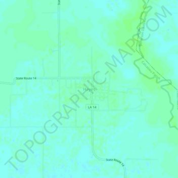
Name: Topografische Karte Hayes, Höhe, Relief.
Ort: Hayes, Calcasieu Parish, Louisiana, 70646, United States (30.08922 -92.94100 30.12922 -92.90100)
Durchschnittliche Höhe: 4 m
Minimale Höhe: 0 m
Maximale Höhe: 8 m
Spenden
Rüste dich für dein nächstes Abenteuer:
Als Amazon-Partner verdient diese Seite an qualifizierten Käufen, ohne dass Ihnen zusätzliche Kosten entstehen.
Andere topografische Karten
Klicken Sie auf eine Karte, um ihre Topografie, ihre Höhe und ihr Relief anzuzeigen.
Lake Charles
United States > Louisiana > Calcasieu Parish
Lake Charles, located on a level plain about 30 miles (48 km) from the Gulf of Mexico, has an elevation of approximately 13 feet (4.0 m) above sea level, and is located on the banks of the Calcasieu River in southwestern Louisiana. It borders both Lake Charles and Prien Lake. Contraband Bayou, Henderson Bayou,…
Durchschnittliche Höhe: 5 m
Spenden
Rüste dich für dein nächstes Abenteuer:
Als Amazon-Partner verdient diese Seite an qualifizierten Käufen, ohne dass Ihnen zusätzliche Kosten entstehen.
Lake Charles
United States > Louisiana > Calcasieu Parish
Lake Charles, located on a level plain about 30 miles (48 km) from the Gulf of Mexico, has an elevation around 13 feet (4.0 meters) above sea level, and is located on the banks of the Calcasieu River in southwestern Louisiana. It borders both Lake Charles and Prien Lake. Contraband Bayou, Henderson Bayou, and…
Durchschnittliche Höhe: 5 m
Lake Charles
United States > Louisiana > Calcasieu Parish
Lake Charles, located on a level plain about 30 miles (48 km) from the Gulf of Mexico, has an elevation of approximately 13 feet (4.0 m) above sea level, and is located on the banks of the Calcasieu River in southwestern Louisiana. It borders both Lake Charles and Prien Lake. Contraband Bayou, Henderson Bayou,…
Durchschnittliche Höhe: 5 m
Spenden
Rüste dich für dein nächstes Abenteuer:
Als Amazon-Partner verdient diese Seite an qualifizierten Käufen, ohne dass Ihnen zusätzliche Kosten entstehen.