Geolokalisieren
👉 Easily get elevation data in JSON, GeoTIFF and KML formats using Elevation API
Vielen Dank für die Unterstützung dieser Website ❤️
Spenden

Topografische Karte Corgo

Klicken Sie auf die Karte, um die Höhe anzuzeigen.

Corgo

El relieve del municipio es ondulado, con elevaciones y valles que forman los numerosos ríos y arroyos que lo atraviesan. Su río principal es el Miño, que hace de límite con Lugo por el suroeste, y los complementarios son el Chamoso, Tórdea, Neira, Romeán y Riobó, entre otros. Las elevaciones más destacadas son Pena Curral (789 m), Pena da Cruz (747 m) Pena do Picato (637 m) y Castro de Vigo (603 m).​ La altitud oscila entre los 789 metros al este y los 357 metros a orillas del Miño. El pueblo se alza a 430 metros sobre el nivel del mar.

Wikipedia (CC-BY-SA 3.0)

👉 Easily get elevation data in JSON, GeoTIFF and KML formats using Elevation API
Vielen Dank für die Unterstützung dieser Website ❤️
Spenden

Über diese Karte

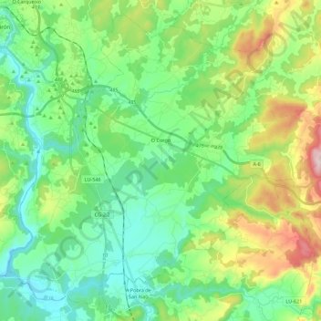
Name: Topografische Karte Corgo, Höhe, Relief.

Ort: Corgo, Lugo, Galicia, España (42.85815 -7.53617 43.00665 -7.31424)

Durchschnittliche Höhe: 466 m

Minimale Höhe: 344 m

Maximale Höhe: 775 m

Andere topografische Karten

Klicken Sie auf eine Karte, um ihre Topografie, ihre Höhe und ihr Relief anzuzeigen.

Tórdea

España > Galicia > Lugo > Castroverde

Durchschnittliche Höhe: 528 m

O Picato

España > Galicia > Lugo > Lugo

Durchschnittliche Höhe: 650 m

Lousada

España > Galicia > Lugo > Portomarín

Durchschnittliche Höhe: 474 m

A Laciana

España > Galicia > Lugo > Outeiro de Rei

Durchschnittliche Höhe: 423 m

O Cordal

España > Galicia > Lugo

Durchschnittliche Höhe: 469 m

Santoalla

España > Galicia > Lugo

Durchschnittliche Höhe: 394 m

Paredes

España > Galicia > Lugo

Durchschnittliche Höhe: 431 m

Páramo

España > Galicia > Lugo > Castroverde

Durchschnittliche Höhe: 696 m

Bascuas

España > Galicia > Lugo

Durchschnittliche Höhe: 520 m

Montouto

España > Galicia > Lugo > Guntín > Montouto

Durchschnittliche Höhe: 604 m

As Donas

España > Galicia > Lugo > Friol

Durchschnittliche Höhe: 525 m

Corno do Boi

España > Galicia > Lugo > Friol

Durchschnittliche Höhe: 710 m

Mourelle

España > Galicia > Lugo > Corgo

Durchschnittliche Höhe: 404 m

Vendas de Narón

España > Galicia > Lugo > Portomarín

Durchschnittliche Höhe: 659 m

O Hospital

España > Galicia > Lugo > Portomarín

Durchschnittliche Höhe: 641 m

Toxibó

España > Galicia > Lugo > Portomarín

Durchschnittliche Höhe: 476 m

Vielen Dank für die Unterstützung dieser Website ❤️
Spenden

Bosende de Arriba

España > Galicia > Lugo

Durchschnittliche Höhe: 434 m

Teicelle

España > Galicia > Lugo

Durchschnittliche Höhe: 621 m

Serra do Careón

España > Galicia > Lugo > Friol

Con una altitud media de 550 metros y máxima de 798 metros, en el monte Careón. Dominan los granitos intrusivos, gneis de "ojo de sapo" y esquistos. En esta sierra nacen el río Narla, afluente del Miño, y el río Pambre, el río Seco y el río Furelos, afluentes los tres del río Ulla.

Durchschnittliche Höhe: 730 m

Lousada

España > Galicia > Lugo

Durchschnittliche Höhe: 533 m

Vielen Dank für die Unterstützung dieser Website ❤️
Spenden

Rüste dich für dein nächstes Abenteuer:

Als Amazon-Partner verdient diese Seite an qualifizierten Käufen, ohne dass Ihnen zusätzliche Kosten entstehen.

Anxeriz

España > Galicia > Lugo > Friol

Durchschnittliche Höhe: 490 m

Pacios

España > Galicia > Lugo

Durchschnittliche Höhe: 502 m

Currelos

España > Galicia > Lugo

Durchschnittliche Höhe: 566 m

Golmar

España > Galicia > Lugo

Durchschnittliche Höhe: 530 m

O Burgo

España > Galicia > Lugo

Durchschnittliche Höhe: 552 m

Santa Mariña

España > Galicia > Lugo > Corgo

Durchschnittliche Höhe: 439 m

Santa Euxea

España > Galicia > Lugo

Durchschnittliche Höhe: 468 m

Devesos

España > Galicia > Lugo > Friol

Durchschnittliche Höhe: 591 m

Biduedo

España > Galicia > Lugo > Portomarín

Durchschnittliche Höhe: 570 m

Gandoi

España > Galicia > Lugo

Durchschnittliche Höhe: 607 m

Os Silgueiros

España > Galicia > Lugo

Durchschnittliche Höhe: 466 m

Aspai

España > Galicia > Lugo > Outeiro de Rei

Durchschnittliche Höhe: 474 m

Chamoso

España > Galicia > Lugo > Corgo

Durchschnittliche Höhe: 435 m

A Eirexe

España > Galicia > Lugo > Portomarín

Durchschnittliche Höhe: 469 m

Cabarcos

España > Galicia > Lugo > Outeiro de Rei > Vilela Pequena

Durchschnittliche Höhe: 411 m

San Cosme de Barreiros

España > Galicia > Lugo > Castroverde

Durchschnittliche Höhe: 622 m

A Graña

España > Galicia > Lugo > Castroverde > A Graña

Durchschnittliche Höhe: 635 m

Segade

España > Galicia > Lugo > Lugo > Segade

Durchschnittliche Höhe: 575 m

Leboriz

España > Galicia > Lugo > Guntín

Durchschnittliche Höhe: 392 m

Vilarreal

España > Galicia > Lugo > Guntín > Vilarreal

Durchschnittliche Höhe: 604 m

O Xuriz

España > Galicia > Lugo > Guntín

Durchschnittliche Höhe: 601 m

Santa Isabel

España > Galicia > Lugo > Outeiro de Rei

Durchschnittliche Höhe: 412 m

O Latadal

España > Galicia > Lugo > Castroverde

Durchschnittliche Höhe: 796 m

Aspai

España > Galicia > Lugo > Outeiro de Rei

Durchschnittliche Höhe: 474 m

Corvelle

España > Galicia > Lugo

Durchschnittliche Höhe: 444 m

Vilar dos Naraos

España > Galicia > Lugo > Castroverde

Durchschnittliche Höhe: 558 m

Pradeda

España > Galicia > Lugo > Friol

Durchschnittliche Höhe: 530 m

Rüste dich für dein nächstes Abenteuer:

👖Zipp-Off Wanderhosen - Flexibilität bei wechselndem Bergwetter
🧼Schuhpflege‑Sets - Pflege für langlebige Wander‑ und Outdoor‑Schuhe
🧣Multifunktionstücher - Vielseitige Tücher für Schutz vor Wind, Sonne und Kälte
🔦LED-Taschenlampen - Zuverlässige Lichtquelle für Notfälle und Camping
🍲Outdoor‑Geschirrsets - Leichte und robuste Sets für Essen unterwegs

Als Amazon-Partner verdient diese Seite an qualifizierten Käufen, ohne dass Ihnen zusätzliche Kosten entstehen.