
Topografische Karte Theodore Roosevelt National Park
Interaktive Karte
Klicken Sie auf die Karte, um die Höhe anzuzeigen.
Über diese Karte
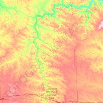
Name: Topografische Karte Theodore Roosevelt National Park, Höhe, Relief.
Durchschnittliche Höhe: 756 m
Minimale Höhe: 573 m
Maximale Höhe: 1’000 m
The wilderness protects from development the wildest sections of the National Park, an area described as badlands where erosional forces have carved steep cliffs into the relatively flat prairie. Bison, pronghorn, elk, mule deer and coyote are all found here, along with hundreds of species of birds such as the bald eagle, falcon and hawk. The wilderness is separated into two sections along with the park, a north and a south unit, by a distance of 70 miles (110 km). The Little Missouri River is on the south side of both units and is credited for being the primary erosional source which created the badlands topography.
Andere topografische Karten
Klicken Sie auf eine Karte, um ihre Topografie, ihre Höhe und ihr Relief anzuzeigen.
Medora
United States > North Dakota > Billings County
Medora, Billings County, North Dakota, 58645, United States
Durchschnittliche Höhe: 720 m