Geolokalisieren

Topografische Karte Fencott

Klicken Sie auf die Karte, um die Höhe anzuzeigen.

Über diese Karte

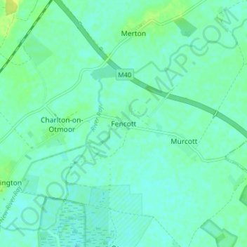
Name: Topografische Karte Fencott, Höhe, Relief.

Ort: Fencott, Cherwell District, Oxfordshire, England, OX5 2RD, United Kingdom (51.81997 -1.18743 51.85997 -1.14743)

Durchschnittliche Höhe: 61 m

Minimale Höhe: 56 m

Maximale Höhe: 71 m

Andere topografische Karten

Klicken Sie auf eine Karte, um ihre Topografie, ihre Höhe und ihr Relief anzuzeigen.

Bicester

United Kingdom > England > Oxfordshire > Cherwell District

Bicester has expanded rapidly in recent generations due to the town's picturesque historical town centre, garden town layout, independent and high-street shops, restaurants, as well as a rail connection to Oxford. It also boasts imminent connection to Cambridge, as well as rail links to Birmingham and London.…

Durchschnittliche Höhe: 77 m

Merton

United Kingdom > England > Oxfordshire > Cherwell District

Durchschnittliche Höhe: 63 m

Hornton

United Kingdom > England > Oxfordshire > Cherwell District

Durchschnittliche Höhe: 172 m

Tadmarton

United Kingdom > England > Oxfordshire > Cherwell District

Durchschnittliche Höhe: 143 m

North Newington

United Kingdom > England > Oxfordshire > Cherwell District

Durchschnittliche Höhe: 137 m

Shutford

United Kingdom > England > Oxfordshire > Cherwell District

Durchschnittliche Höhe: 154 m

Banbury

United Kingdom > England > Oxfordshire > Cherwell District

Durchschnittliche Höhe: 116 m

Bloxham

United Kingdom > England > Oxfordshire > Cherwell District

Durchschnittliche Höhe: 115 m

Adderbury

United Kingdom > England > Oxfordshire > Cherwell District

Durchschnittliche Höhe: 100 m

Sibford Ferris

United Kingdom > England > Oxfordshire > Cherwell District

Durchschnittliche Höhe: 173 m

Ambrosden

United Kingdom > England > Oxfordshire > Cherwell District

Durchschnittliche Höhe: 65 m

Finmere

United Kingdom > England > Oxfordshire > Cherwell District

Durchschnittliche Höhe: 114 m

Blackthorn

United Kingdom > England > Oxfordshire > Cherwell District

Durchschnittliche Höhe: 64 m

The Lake

United Kingdom > England > Oxfordshire > Cherwell District > Hardwick

Durchschnittliche Höhe: 120 m

Milton

United Kingdom > England > Oxfordshire > Cherwell District

Durchschnittliche Höhe: 111 m

Stoke Lyne

United Kingdom > England > Oxfordshire > Cherwell District > Stoke Lyne

Durchschnittliche Höhe: 116 m

Epwell

United Kingdom > England > Oxfordshire > Cherwell District

Durchschnittliche Höhe: 181 m

Wardington

United Kingdom > England > Oxfordshire > Cherwell District

Durchschnittliche Höhe: 125 m

Souldern

United Kingdom > England > Oxfordshire > Cherwell District

Durchschnittliche Höhe: 115 m

Noke

United Kingdom > England > Oxfordshire > Cherwell District

Durchschnittliche Höhe: 68 m

Fringford

United Kingdom > England > Oxfordshire > Cherwell District

Durchschnittliche Höhe: 99 m

Swalcliffe

United Kingdom > England > Oxfordshire > Cherwell District

Durchschnittliche Höhe: 163 m

Yarnton

United Kingdom > England > Oxfordshire > Cherwell District

Durchschnittliche Höhe: 68 m

Horley

United Kingdom > England > Oxfordshire > Cherwell District

Durchschnittliche Höhe: 146 m

River Ray

United Kingdom > England > Oxfordshire > Cherwell District

Durchschnittliche Höhe: 83 m

Begbroke

United Kingdom > England > Oxfordshire > Cherwell District > Begbroke

Durchschnittliche Höhe: 75 m

Launton

United Kingdom > England > Oxfordshire > Cherwell District

Durchschnittliche Höhe: 73 m

Bloxham

United Kingdom > England > Oxfordshire > Cherwell District

Durchschnittliche Höhe: 115 m

Banbury

United Kingdom > England > Oxfordshire > Cherwell District

Durchschnittliche Höhe: 116 m

Kidlington

United Kingdom > England > Oxfordshire > Cherwell District

Durchschnittliche Höhe: 68 m

Duns Tew

United Kingdom > England > Oxfordshire > Cherwell District

Durchschnittliche Höhe: 125 m

Hook Norton

United Kingdom > England > Oxfordshire > Cherwell District

Durchschnittliche Höhe: 172 m

Upper Heyford

United Kingdom > England > Oxfordshire > Cherwell District

Durchschnittliche Höhe: 101 m

Fritwell

United Kingdom > England > Oxfordshire > Cherwell District

Durchschnittliche Höhe: 128 m

Mixbury

United Kingdom > England > Oxfordshire > Cherwell District

Durchschnittliche Höhe: 120 m

Piddington

United Kingdom > England > Oxfordshire > Cherwell District

Durchschnittliche Höhe: 81 m

Vielen Dank für die Unterstützung dieser Website ❤️
Spenden

Arncott

United Kingdom > England > Oxfordshire > Cherwell District

Durchschnittliche Höhe: 68 m

Oddington

United Kingdom > England > Oxfordshire > Cherwell District

Durchschnittliche Höhe: 62 m

Wendlebury

United Kingdom > England > Oxfordshire > Cherwell District

Durchschnittliche Höhe: 65 m

Kidlington

United Kingdom > England > Oxfordshire > Cherwell District

Durchschnittliche Höhe: 68 m

Ardley

United Kingdom > England > Oxfordshire > Cherwell District

Durchschnittliche Höhe: 119 m

Milcombe

United Kingdom > England > Oxfordshire > Cherwell District

Durchschnittliche Höhe: 146 m

Bletchingdon

United Kingdom > England > Oxfordshire > Cherwell District

Durchschnittliche Höhe: 76 m

Sibford Gower

United Kingdom > England > Oxfordshire > Cherwell District

Durchschnittliche Höhe: 171 m

Deddington

United Kingdom > England > Oxfordshire > Cherwell District

Clifton, Deddington and Hempton stand on a ridge of Jurassic ferruginous marlstone hills between the three watercourses. Clifton is about 1+1⁄2 miles (2.4 km) east of Deddington, at the eastern end of the ridge where it slopes down to the Cherwell. The ridges rises westward. Deddington is about 430 feet (130…

Durchschnittliche Höhe: 107 m

Kirtlington

United Kingdom > England > Oxfordshire > Cherwell District

Durchschnittliche Höhe: 89 m

Bodicote

United Kingdom > England > Oxfordshire > Cherwell District

Durchschnittliche Höhe: 114 m

Wigginton

United Kingdom > England > Oxfordshire > Cherwell District

Durchschnittliche Höhe: 154 m

Cropredy

United Kingdom > England > Oxfordshire > Cherwell District > Cropredy

Durchschnittliche Höhe: 124 m

North Aston

United Kingdom > England > Oxfordshire > Cherwell District

Durchschnittliche Höhe: 101 m

Wroxton

United Kingdom > England > Oxfordshire > Cherwell District

Durchschnittliche Höhe: 146 m

Islip

United Kingdom > England > Oxfordshire > Cherwell District > Islip

Durchschnittliche Höhe: 65 m

Lower Heyford

United Kingdom > England > Oxfordshire > Cherwell District

Durchschnittliche Höhe: 99 m

Bucknell

United Kingdom > England > Oxfordshire > Cherwell District

Durchschnittliche Höhe: 99 m

Steeple Aston

United Kingdom > England > Oxfordshire > Cherwell District

Durchschnittliche Höhe: 107 m

Bucknell

United Kingdom > England > Oxfordshire > Cherwell District

Durchschnittliche Höhe: 99 m

Rüste dich für dein nächstes Abenteuer:

💧Outdoor Wasserfilter - Zuverlässige Filterlösungen für sauberes Trinkwasser unterwegs
🧗‍♂️Grundausrüstung Klettern - Klettergurte, Karabiner und Zubehör für Einsteiger
🆘Biwaksäcke - Lebensrettender Schutz bei Wetterumstürzen im Gebirge
🧪Wasser‑Teststreifen - Test zur Sicherstellung von Trinkwasserqualität
🔥Campingkocher & Outdoor‑Kocher - Leistungsstarke Kocher für Wander‑ und Trekkingtouren

Als Amazon-Partner verdient diese Seite an qualifizierten Käufen, ohne dass Ihnen zusätzliche Kosten entstehen.