
Spenden
Rüste dich für dein nächstes Abenteuer:
Als Amazon-Partner verdient diese Seite an qualifizierten Käufen, ohne dass Ihnen zusätzliche Kosten entstehen.
Topografische Karte Sand Pass
Klicken Sie auf die Karte, um die Höhe anzuzeigen.
Spenden
Rüste dich für dein nächstes Abenteuer:
Als Amazon-Partner verdient diese Seite an qualifizierten Käufen, ohne dass Ihnen zusätzliche Kosten entstehen.
Über diese Karte
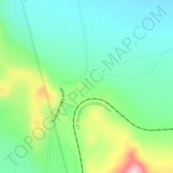
Name: Topografische Karte Sand Pass, Höhe, Relief.
Ort: Sand Pass, Washoe County, Nevada, United States (40.25149 -119.78938 40.27149 -119.76938)
Durchschnittliche Höhe: 1’255 m
Minimale Höhe: 1’186 m
Maximale Höhe: 1’416 m
Spenden
Rüste dich für dein nächstes Abenteuer:
Als Amazon-Partner verdient diese Seite an qualifizierten Käufen, ohne dass Ihnen zusätzliche Kosten entstehen.
Andere topografische Karten
Klicken Sie auf eine Karte, um ihre Topografie, ihre Höhe und ihr Relief anzuzeigen.
Reno
United States > Nevada > Washoe County
Reno is characterized by its diverse topography, which is shaped by its elevation and the surrounding mountain ranges. Situated at an average elevation of approximately 4,500 feet (about 1,370 meters), the city is nestled in a high desert region that features a mix of flat valleys and gently rolling hills.…
Durchschnittliche Höhe: 1’650 m
Reno
United States > Nevada > Washoe County
Reno is just east of the Sierra Nevada on the western edge of the Great Basin at an elevation of about 4,400 feet (1,300 m) above sea level. Numerous faults exist throughout the region. Most of these are normal (vertical motion) faults associated with the uplift of the various mountain ranges, including the…
Durchschnittliche Höhe: 1’650 m
Spenden
Rüste dich für dein nächstes Abenteuer:
Als Amazon-Partner verdient diese Seite an qualifizierten Käufen, ohne dass Ihnen zusätzliche Kosten entstehen.
Spanish Springs
United States > Nevada > Washoe County > Spanish Springs
Durchschnittliche Höhe: 1’564 m
Incline Village-Crystal Bay
United States > Nevada > Washoe County > Incline Village-Crystal Bay
Durchschnittliche Höhe: 2’173 m
Spooner Lake & Backcountry State Park
United States > Nevada > Washoe County > Incline Village-Crystal Bay
Durchschnittliche Höhe: 2’108 m
Spenden
Rüste dich für dein nächstes Abenteuer:
Als Amazon-Partner verdient diese Seite an qualifizierten Käufen, ohne dass Ihnen zusätzliche Kosten entstehen.
Reno
United States > Nevada > Washoe County
Reno is just east of the Sierra Nevada, on the western edge of the Great Basin at an elevation of about 4,400 feet (1,300 m) above sea level. Numerous faults exist throughout the region. Most of these are normal (vertical motion) faults associated with the uplift of the various mountain ranges, including the…
Durchschnittliche Höhe: 1’650 m
New Washoe City Park
United States > Nevada > Washoe County > Carson City
Durchschnittliche Höhe: 1’550 m
Spenden
Rüste dich für dein nächstes Abenteuer:
Als Amazon-Partner verdient diese Seite an qualifizierten Käufen, ohne dass Ihnen zusätzliche Kosten entstehen.
Reno
United States > Nevada > Washoe County
Reno is just east of the Sierra Nevada, on the western edge of the Great Basin at an elevation of about 4,400 feet (1,300 m) above sea level. Numerous faults exist throughout the region. Most of these are normal (vertical motion) faults associated with the extension of the earth's lithosphere and the uplift of…
Durchschnittliche Höhe: 1’650 m
Reno
United States > Nevada > Washoe County
Reno is just east of the Sierra Nevada, on the western edge of the Great Basin at an elevation of about 4,400 feet (1,300 m) above sea level. Numerous faults exist throughout the region. Most of these are normal (vertical motion) faults associated with the uplift of the various mountain ranges, including the…
Durchschnittliche Höhe: 1’650 m
Reno
United States > Nevada > Washoe County
Reno is just east of the Sierra Nevada, on the western edge of the Great Basin at an elevation of about 4,400 feet (1,300 m) above sea level. Numerous faults exist throughout the region. Most of these are normal (vertical motion) faults associated with the extension of the earth's lithosphere and the uplift of…
Durchschnittliche Höhe: 1’650 m
Spenden
Rüste dich für dein nächstes Abenteuer:
Als Amazon-Partner verdient diese Seite an qualifizierten Käufen, ohne dass Ihnen zusätzliche Kosten entstehen.
Incline Village-Crystal Bay
United States > Nevada > Washoe County > Incline Village-Crystal Bay
Durchschnittliche Höhe: 2’173 m
Reno
United States > Nevada > Washoe County
Reno is just east of the Sierra Nevada, on the western edge of the Great Basin at an elevation of about 4,400 feet (1,300 m) above sea level. Numerous faults exist throughout the region. Most of these are normal (vertical motion) faults associated with the uplift of the various mountain ranges, including the…
Durchschnittliche Höhe: 1’650 m
Spenden
Rüste dich für dein nächstes Abenteuer:
Als Amazon-Partner verdient diese Seite an qualifizierten Käufen, ohne dass Ihnen zusätzliche Kosten entstehen.
Oxbow Nature Study Area
United States > Nevada > Washoe County > Reno > West Reno
Durchschnittliche Höhe: 1’415 m