
Topografische Karte Fourmile
Interaktive Karte
Klicken Sie auf die Karte, um die Höhe anzuzeigen.
Über diese Karte
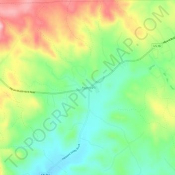
Name: Topografische Karte Fourmile, Höhe, Relief.
Ort: Fourmile, Custer County, South Dakota, United States (43.71276 -103.69547 43.75276 -103.65547)
Durchschnittliche Höhe: 1’669 m
Minimale Höhe: 1’598 m
Maximale Höhe: 1’771 m
Andere topografische Karten
Klicken Sie auf eine Karte, um ihre Topografie, ihre Höhe und ihr Relief anzuzeigen.
Custer State Park
United States > South Dakota > Custer County
Custer State Park, Custer County, South Dakota, United States
Durchschnittliche Höhe: 1’413 m
Stockade Lake
United States > South Dakota > Custer County
Stockade Lake, Custer County, South Dakota, United States
Durchschnittliche Höhe: 1’616 m
Hermosa
United States > South Dakota > Custer County
Hermosa, Custer County, South Dakota, United States
Durchschnittliche Höhe: 1’010 m
Spokane
United States > South Dakota > Custer County
Spokane, Custer County, South Dakota, United States
Durchschnittliche Höhe: 1’394 m
Sylvan Lake Resort
United States > South Dakota > Custer County
Sylvan Lake Resort, Custer County, South Dakota, United States
Durchschnittliche Höhe: 1’889 m
State Game Lodge
United States > South Dakota > Custer County
State Game Lodge, Custer County, South Dakota, United States
Durchschnittliche Höhe: 1’348 m
Berne
United States > South Dakota > Custer County
Berne, Custer County, South Dakota, United States
Durchschnittliche Höhe: 1’799 m
Buffalo Gap
United States > South Dakota > Custer County
Buffalo Gap, Custer County, South Dakota, 57722, United States
Durchschnittliche Höhe: 1’005 m
Wind Cave National Park
United States > South Dakota > Custer County
Wind Cave National Park, Custer County, South Dakota, United States
Durchschnittliche Höhe: 1’315 m