
Topografische Karte Hebron
Interaktive Karte
Klicken Sie auf die Karte, um die Höhe anzuzeigen.
Über diese Karte
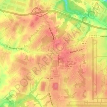
Name: Topografische Karte Hebron, Höhe, Relief.
Ort: Hebron, Boone County, Kentucky, 41048, United States (39.04581 -84.72276 39.08581 -84.68276)
Durchschnittliche Höhe: 263 m
Minimale Höhe: 212 m
Maximale Höhe: 283 m
Andere topografische Karten
Klicken Sie auf eine Karte, um ihre Topografie, ihre Höhe und ihr Relief anzuzeigen.
Burlington
United States > Kentucky > Boone County
Burlington, Boone County, Kentucky, 41005, United States
Durchschnittliche Höhe: 250 m
Verona
United States > Kentucky > Boone County
Verona, Boone County, Kentucky, 41092, United States
Durchschnittliche Höhe: 259 m
Florence
United States > Kentucky > Boone County
Florence, Boone County, Kentucky, 41042, United States
Durchschnittliche Höhe: 265 m
Walton
United States > Kentucky > Boone County
Walton, Boone County, Kentucky, United States
Durchschnittliche Höhe: 264 m
Union
United States > Kentucky > Boone County
Union, Boone County, Kentucky, 41091, United States
Durchschnittliche Höhe: 265 m
Big Bone Lick State Park
United States > Kentucky > Boone County > Big Bone
Big Bone Lick State Park, Big Bone, Boone County, Kentucky, United States
Durchschnittliche Höhe: 179 m