
Topografische Karte Falzarego Pass
Interaktive Karte
Klicken Sie auf die Karte, um die Höhe anzuzeigen.
Über diese Karte
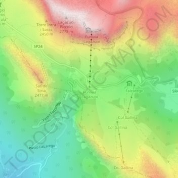
Name: Topografische Karte Falzarego Pass, Höhe, Relief.
Ort: Falzarego Pass, Cortina d'Ampezzo, Belluno, Veneto, Italy (46.51870 12.00838 46.51880 12.00848)
Durchschnittliche Höhe: 2’179 m
Minimale Höhe: 1’736 m
Maximale Höhe: 2’757 m
Andere topografische Karten
Klicken Sie auf eine Karte, um ihre Topografie, ihre Höhe und ihr Relief anzuzeigen.
Pocol
Italy > Veneto > Belluno > Cortina d'Ampezzo
Pocol, Cortina d'Ampezzo, Belluno, Veneto, 32043, Italy
Durchschnittliche Höhe: 1’448 m
Gruppo del Pomagagnon
Italy > Veneto > Belluno > Cortina d'Ampezzo
Gruppo del Pomagagnon, Cortina d'Ampezzo, Belluno, Veneto, 32043, Italy
Durchschnittliche Höhe: 1’758 m
Cinque Torri
Italy > Veneto > Belluno > Cortina d'Ampezzo
Cinque Torri, Cortina d'Ampezzo, Belluno, Veneto, Italy
Durchschnittliche Höhe: 2’071 m