
Topografische Karte Ebbsfleet
Klicken Sie auf die Karte, um die Höhe anzuzeigen.
Über diese Karte
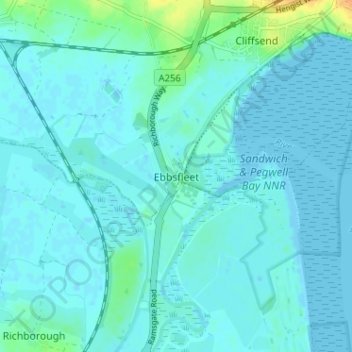
Name: Topografische Karte Ebbsfleet, Höhe, Relief.
Ort: Ebbsfleet, Thanet, Kent, England, CT12 5DH, United Kingdom (51.29352 1.33114 51.33352 1.37114)
Durchschnittliche Höhe: 4 m
Minimale Höhe: -2 m
Maximale Höhe: 32 m
Andere topografische Karten
Klicken Sie auf eine Karte, um ihre Topografie, ihre Höhe und ihr Relief anzuzeigen.
Ramsgate
United Kingdom > England > Kent > Thanet > Pegwell
In 2017 Ramsgate was chosen as one of the first ten Heritage Action Zones (HAZ) by Historic England, with the aim of stimulating economic growth by taking advantage of Ramsgate's historic environment. Part of this project included a Historic Landscape Characterisation Study which assessed and mapped the…
Durchschnittliche Höhe: 25 m
Ramsgate
United Kingdom > England > Kent > Thanet
In 2017 Ramsgate was chosen as one of the first ten Heritage Action Zones (HAZ) by Historic England, with the aim of stimulating economic growth using Ramsgate's historic environment as a catalyst. Part of this project included a Historic Landscape Characterisation Study which assessed and mapped the patterns…
Durchschnittliche Höhe: 25 m