
Topografische Karte Columbia
Interaktive Karte
Klicken Sie auf die Karte, um die Höhe anzuzeigen.
Über diese Karte
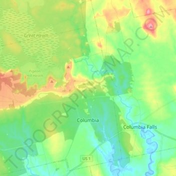
Name: Topografische Karte Columbia, Höhe, Relief.
Ort: Columbia, Washington County, Maine, 04623, United States (44.62222 -67.89206 44.73480 -67.74389)
Durchschnittliche Höhe: 40 m
Minimale Höhe: -3 m
Maximale Höhe: 120 m
Columbia is located in a region of massive granite intrusion that was glaciated in the Wisconsin age. The glacier caused till (unsorted, poorly drained soil) to be deposited over the entire region. This poorly drained till formed bogs and ponds and altered the drainage pattern. The underlying granite caused the till to be more thickly deposited on the northwest sides of ridges: on the southeast sides boulders were "plucked" and transported further south. Thick till deposits are also found in bedrock "valleys" and depressions. The weight of the ice (in some places a mile thick) caused the land to be depressed in relation to the level of the sea. Marine sediments (silts and clays) were deposited in valleys and more sheltered locations. The release of pressure due to the melting allowed the land to rise slowly. This explains why silt and clay deposits can be found at elevations of 100 feet (30 m) or more. Columbia contains the largest and most significant areas of marine outwash plain resulting in regionally significant deposits of sand and gravel.