
Spenden
Rüste dich für dein nächstes Abenteuer:
Als Amazon-Partner verdient diese Seite an qualifizierten Käufen, ohne dass Ihnen zusätzliche Kosten entstehen.
Topografische Karte Dolly Sods Wilderness
Klicken Sie auf die Karte, um die Höhe anzuzeigen.
Spenden
Rüste dich für dein nächstes Abenteuer:
Als Amazon-Partner verdient diese Seite an qualifizierten Käufen, ohne dass Ihnen zusätzliche Kosten entstehen.
Über diese Karte
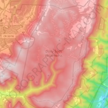
Name: Topografische Karte Dolly Sods Wilderness, Höhe, Relief.
Durchschnittliche Höhe: 1’041 m
Minimale Höhe: 347 m
Maximale Höhe: 1’351 m
Spenden
Rüste dich für dein nächstes Abenteuer:
Als Amazon-Partner verdient diese Seite an qualifizierten Käufen, ohne dass Ihnen zusätzliche Kosten entstehen.
Andere topografische Karten
Klicken Sie auf eine Karte, um ihre Topografie, ihre Höhe und ihr Relief anzuzeigen.
Davis
United States > West Virginia > Tucker County
At an elevation of 3,520 feet, Davis has the highest elevation of any West Virginia town.
Durchschnittliche Höhe: 963 m
Dolly Sods Wilderness
United States > West Virginia > Tucker County
Dolly Sods is a rocky, high-altitude plateau with sweeping vistas and lifeforms normally found much farther north in Canada. To the north, the distinctive landscape of "the Sods" is characterized by stunted ("flagged") trees, wind-carved boulders, heath barrens, grassy meadows created in the last century by…
Durchschnittliche Höhe: 1’042 m
Spenden
Rüste dich für dein nächstes Abenteuer:
Als Amazon-Partner verdient diese Seite an qualifizierten Käufen, ohne dass Ihnen zusätzliche Kosten entstehen.
Davis
United States > West Virginia > Tucker County
At an elevation of 3,520 feet, Davis has the highest elevation of any West Virginia town. According to the United States Census Bureau, the town has a total area of 1.83 square miles (4.74 km2), all land.
Durchschnittliche Höhe: 963 m
Spenden
Rüste dich für dein nächstes Abenteuer:
Als Amazon-Partner verdient diese Seite an qualifizierten Käufen, ohne dass Ihnen zusätzliche Kosten entstehen.
Davis
United States > West Virginia > Tucker County > Davis
At an elevation of 3,520 feet, Davis has the highest elevation of any West Virginia town.
Durchschnittliche Höhe: 984 m